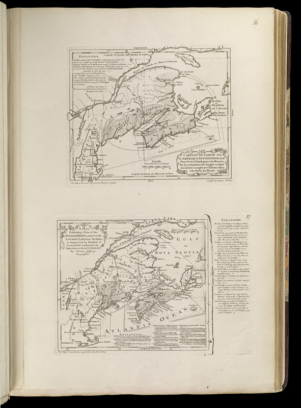
Carte d'une partie de l'Amérique Septentrionale : pour servir à l'intellegence du mémoire sur les prétentions des Anglois au sujét des limites à regler avec la France dans cetter partie du monde
Item Information
- Title:
- Carte d'une partie de l'Amérique Septentrionale : pour servir à l'intellegence du mémoire sur les prétentions des Anglois au sujét des limites à regler avec la France dans cetter partie du monde
- Creator:
- Jefferys, Thomas, -1771
- Publisher:
- Sayer, Robert, 1725-1794
- Name on Item:
-
T. Jefferys sculpsit
- Date:
-
[1768]
- Format:
-
Maps/Atlases
- Location:
-
Boston Public Library
Norman B. Leventhal Map Center - Collection (local):
-
Norman B. Leventhal Map Center Collection
- Subjects:
-
Indians of North America--Acadia--Maps--Early works to 1800
Great Britain--Territories and possessions
New England--Maps--Early works to 1800
Québec (Province)--Maps--Early works to 1800
Maritime Provinces--Maps--Early works to 1800
- Places:
-
CanadaQuebec (province)
New England (area)
- Extent:
- 2 maps on 1 sheet ; 20 x 24 cm. and 19 x 21 cm., on sheet 56 x 37 cm.
- Terms of Use:
-
No known copyright restrictions.
No known restrictions on use.
- Publisher:
-
London :
Printed for Robert Sayer, ... and Thomas Jefferys
- Scale:
-
Scale [ca. 1:4,800,000]
Scale [ca. 1:5,500,000]
- Language:
-
English
- Notes:
-
Prime meridian: Paris.
Includes explanations.
"This map is an exact copy from the French original."
"This map is drawn on the same scale as the French map."
Appears in Jefferys' General topography of North America and the West Indies. London: Printed for Robert Sayer, ... and Thomas Jefferys, 1768.
- Notes (date):
-
This date is inferred.
- Notes (citation):
-
Phillips, 1196
- Identifier:
-
4000137_0034
- Call #:
-
G1105 .J4 1768
- Barcode:
-
30000003254057


