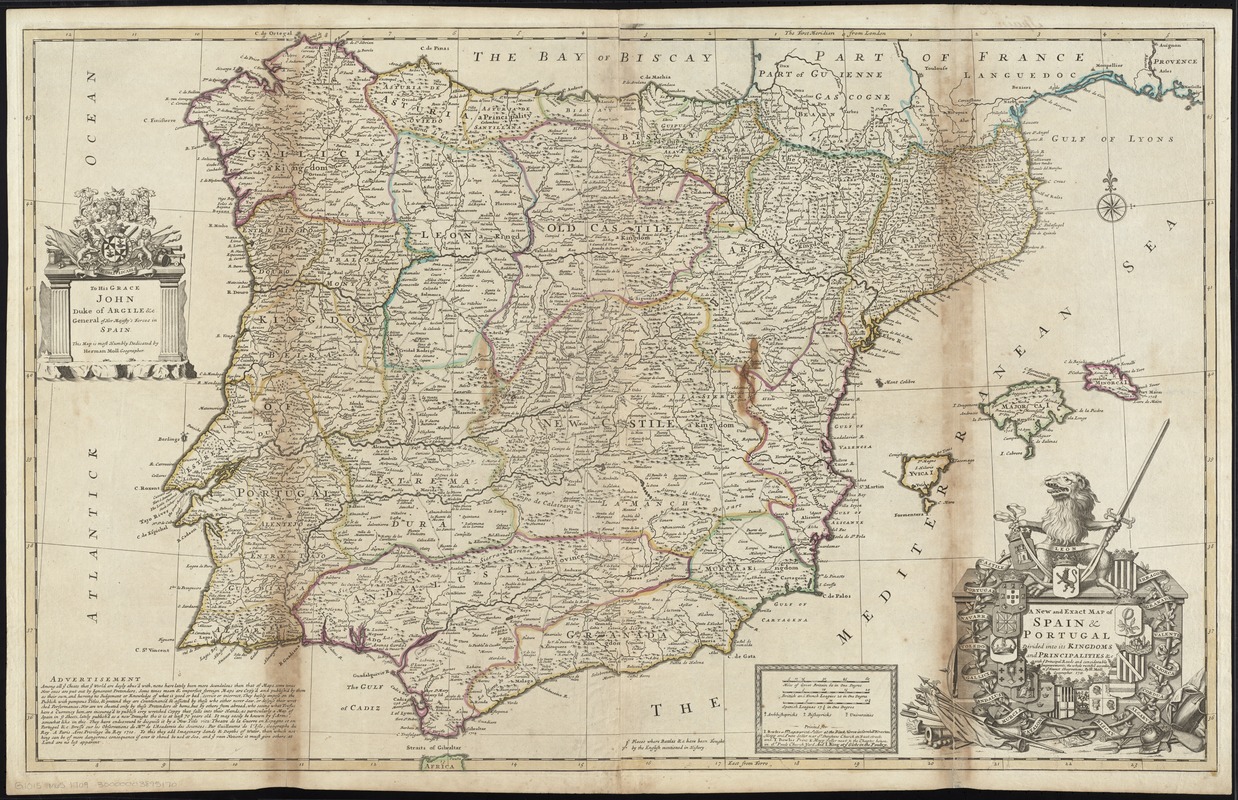
A new and exact map of Spain & Portugal divided into its kingdoms and principalities &c with ye principal roads and considerable improvements
Item Information
- Title:
- A new and exact map of Spain & Portugal divided into its kingdoms and principalities &c with ye principal roads and considerable improvements
- Creator:
- Moll, Herman, d. 1732
- Name on Item:
-
the whole rectify'd according to ye newest observations, by H. Moll Geographer. 1711.
- Date:
-
[1730]
- Format:
-
Maps/Atlases
- Location:
-
Boston Public Library
Norman B. Leventhal Map Center - Collection (local):
-
Norman B. Leventhal Map Center Collection
- Subjects:
-
Iberian Peninsula--Maps--Early works to 1800
Spain--Maps--Early works to 1800
Portugal--Maps--Early works to 1800
Argyll, John Campbell, Duke of, 1680-1743
- Places:
-
Iberian Peninsula (area)
Spain
Portugal
- Extent:
- 1 map : hand col. ; 61 x 97 cm.
- Terms of Use:
-
No known copyright restrictions.
No known restrictions on use.
- Publisher:
-
[London] :
Printed for I. Bowles ... P. Overton ... and T. Bowles ... and I. King
- Scale:
-
Scale [ca. 1:1,550,000]
- Language:
-
English
- Notes:
-
Without Moll's imprint; possibly issued after his death.
Relief shown pictorially.
Prime meridians: London and Ferro.
Dedication: To His Grace John Duke of Argile &c. General of Her Majesty's Forces in Spain. This map is most Humbly Dedicated by Herman Moll Geographer.
Indicates "places where battles &c. have been fought by the English mentioned in history."
Includes advertisement.
Appears in Moll's The world described, [1709-1736], plate 26.
- Notes (date):
-
This date is inferred.
- Identifier:
-
06_01_009683
- Call #:
-
G1015 .M65 1709
- Barcode:
-
30000003895170
![[Hispania]](https://bpldcassets.blob.core.windows.net/derivatives/images/commonwealth:7h14b057s/image_thumbnail_300.jpg)


