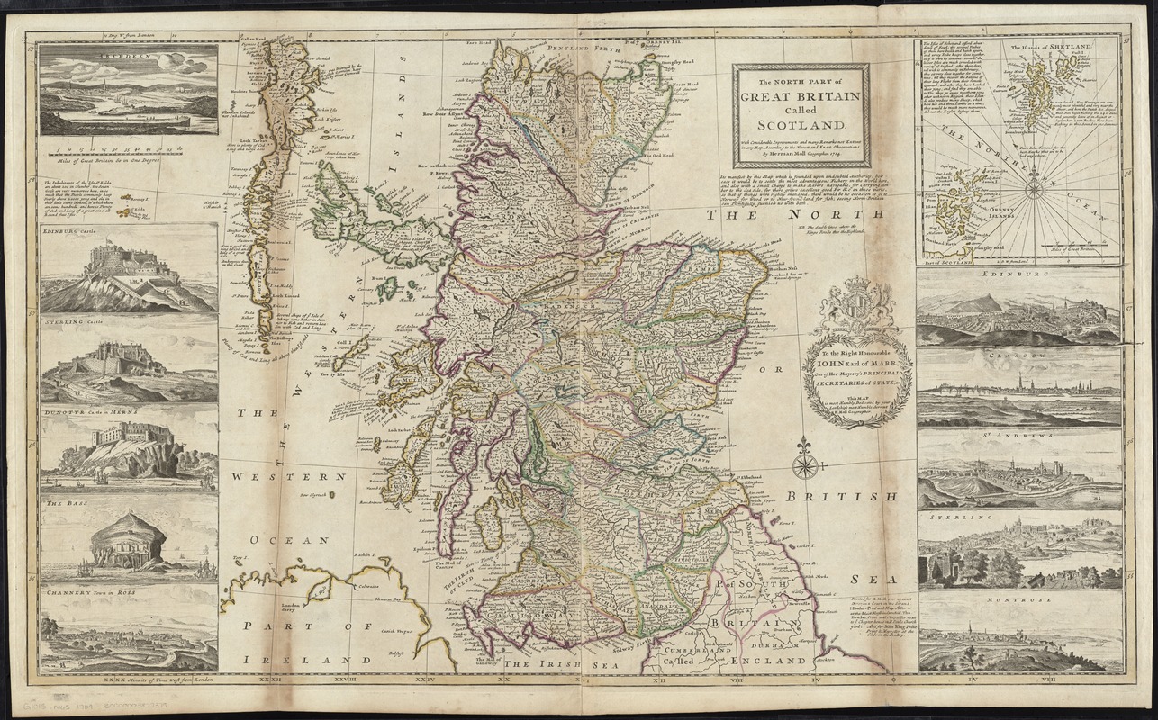
The north part of Great Britain called Scotland : with considerable inprovements [sic] and many remarks not extant in any map, according to the newest and exact observations
Item Information
- Title:
- The north part of Great Britain called Scotland : with considerable inprovements [sic] and many remarks not extant in any map, according to the newest and exact observations
- Creator:
- Moll, Herman, d. 1732
- Name on Item:
-
by Herman Moll Geographer, 1714.
- Date:
-
[1730]
- Format:
-
Maps/Atlases
- Location:
-
Boston Public Library
Norman B. Leventhal Map Center - Collection (local):
-
Norman B. Leventhal Map Center Collection
- Subjects:
-
Scotland--Maps--Early works to 1800
- Places:
-
Scotland
- Extent:
- 1 map : hand col. ; 59 x 100 cm.
- Terms of Use:
-
No known copyright restrictions.
No known restrictions on use.
- Publisher:
-
[London] :
Printed for H. Moll over against Devereux Court on the Strand I. Bowles, Print and Map Seller, at the Black Horse in Cornhill, Tho. Bowles Print and Mapseller next to ye Chapter House in St. Pauls Church yard, and for John King Print Print [sic] & Mapseller at the Globe in the Poultry
- Scale:
-
Scale [ca. 1:910,000]
- Language:
-
English
- Notes:
-
Relief shown pictorially.
Inset: [The Islands of Shetland and the Orkney Islands].
Dedication: To the right honourable John Earl of Marr, one of Her Majesty's principal Secretaries of State, &c. This map is most Humbly Dedicated by your Lordship's most Humble Servent H. Moll Geographer.
Map is bordered on sides and bottom by 11 b&w city and castle views: Edinburg -- Glasgow -- St. Andrews -- Sterling -- Montrose -- Channery Town in Ross -- The Bass -- Dunotyr Castle in Merns -- Sterling Castle -- Edinburg Castle -- Aberdeen.
Appears in Moll's The world described, [1709-1736], plate 18.
- Notes (date):
-
This date is inferred.
- Identifier:
-
06_01_009674
- Call #:
-
G1015 .M65 1709
- Barcode:
-
30000003877375


![Exactissima Regni Scotiae tabula tam in septentrionalem et meriodionalem quam in minores earundem provincias, insulasq[ue] ei undique praetensas accurate divisa](https://bpldcassets.blob.core.windows.net/derivatives/images/commonwealth:cj82kz35d/image_thumbnail_300.jpg)
