To the Right Honourable William, Lord Cowper, Lord High Chancellor of Great Britain, this map of Asia : according to ye newest and most exact observations is most humbly dedicated
Item Information
- Title:
- To the Right Honourable William, Lord Cowper, Lord High Chancellor of Great Britain, this map of Asia : according to ye newest and most exact observations is most humbly dedicated
- Title (alt.):
-
This map of Asia
Asia according to ye newest and most exact observations
- Creator:
- Moll, Herman, d. 1732
- Name on Item:
-
by your Lordship's most humble servant, Herman Moll, geographer.
- Date:
-
[1710–1719]
- Format:
-
Maps/Atlases
- Location:
-
Boston Public Library
Norman B. Leventhal Map Center - Collection (local):
-
Norman B. Leventhal Map Center Collection
- Subjects:
-
Asia--Maps--Early works to 1800
Cowper, William Cowper, Earl, ca. 1665-1723
1715–1718
- Places:
-
Asia
Asia
- Extent:
- 1 map : hand col. ; 57 x 95 cm.
- Terms of Use:
-
No known copyright restrictions.
No known restrictions on use.
- Publisher:
-
[London] :
Printed for H. Moll ... Ino. Bowles & Son ... and Tho. Bowles ... by Philip Overton ... and by John King
- Scale:
-
Scale [ca. 1:19,000,000] at equator
- Language:
-
English
- Notes:
-
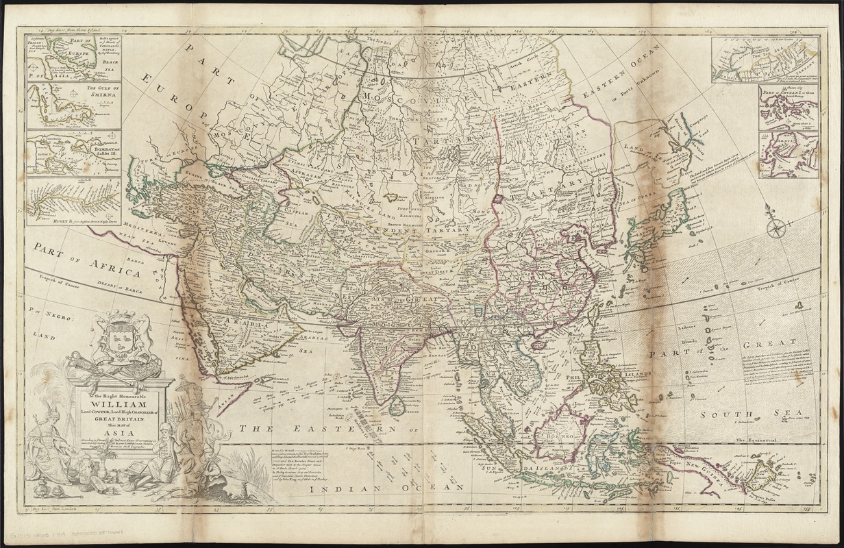
Map of the Middle East and Asia including the East Indies. It features characteristic misconceptions of early 18th century cartography such as New Guinea as a peninsula of the southern continent and Iapon or Niphon [i.e. Japan] having a huge northern island called Land of Iesso [presumably the islands of Hokkaido and Sakhalin].
Prime meridians: Ferro and London.
Relief shown pictorially.
Dedicated to Lord Cowper, High Chancellor of Great Britain from 1714-1718.
Block of text at far right lower side of map indicating that two Jesuit explorers, Paul Clain and Le Gibien, had reported 87 islands found east or south-east of the Philippines but this was not yet confirmed by other explorers.
Insets: Hellespont, or ye Straits of Constantinople -- The Gulf of Smirna -- Bombay and Sallset Isl. -- Hugley R. from Buffalow Point to Hugly Towne -- The Ice Sea -- Part of Chusan I. -- [Amoy Island].
Appears in Moll's The world described, [1709-1736], plate 4.
- Notes (date):
-
This date is inferred.
- Identifier:
-
06_01_009656
- Call #:
-
G1015 .M65 1709
- Barcode:
-
30000003874648


