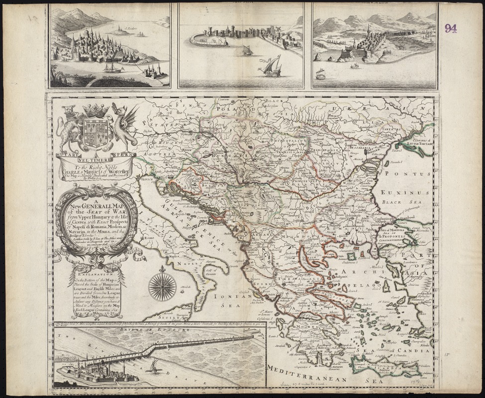
A new generall map of the seat of war from Vpper Hungary to the Isle of Candia : with exact prospects of Napoli di Romania, Modon, &c. Navarin, in the Morèa, and the Bridge of Essecke
Item Information
- Title:
- A new generall map of the seat of war from Vpper Hungary to the Isle of Candia : with exact prospects of Napoli di Romania, Modon, &c. Navarin, in the Morèa, and the Bridge of Essecke
- Title (alt.):
-
New generall map of the seat of war from Upper Hungary to the Isle of Candia
Collection of old maps
- Creator:
- Lea, Philip, fl. 1683-1700
- Name on Item:
-
by Phillip Lea.
- Date:
-
[1695]
- Format:
-
Maps/Atlases
- Location:
-
Boston Public Library
Norman B. Leventhal Map Center - Collection (local):
-
Norman B. Leventhal Map Center Collection
- Subjects:
-
Balkan Peninsula--Maps--Early works to 1800
Balkan Peninsula--Administrative and political divisions--Maps--Early works to 1800
Hungary--Maps--Early works to 1800
- Places:
-
Balkan Peninsula (area)
Hungary
- Extent:
- 1 map : col. ; 39 x 51 cm, on sheet 53 x 64 cm.
- Terms of Use:
-
No known copyright restrictions.
No known restrictions on use.
- Publisher:
-
London :
sold by P. Lea at The Atlas and Hercules in Cheapside and in Westminster Hall
- Scale:
-
Scale [ca. 1:6,500,000]
- Language:
-
English
- Notes:
-
Covers the Balkan Peninsula from Austria to Crete.
Relief shown pictorially.
Does not show military troop positions or installations.
"I. Oliver sculp."
Includes statement of dedication "To the Right Noble Charles Marquess of Worcester", coat-of-arms, textual "Explanation" of the scale, inset view of the Bridge of Essecke", and 3 ancillary city views in upper margin.
Cataloging, conservation, and digitization made possible in part by The National Endowment for the Humanities: Exploring the human endeavor.
Part of composite portfolio atlas with title "Collection of old maps."
- Notes (date):
-
This date is inferred.
- Identifier:
-
06_01_009283
- Call #:
-
G1015 .C65 1630
- Barcode:
-
30000003858175
![Regni Hungariae, et regionum, quae ei quondam fuêre unitae, ut Transilvaniae, Valachiae, Moldaviae, Serviae, Romaniae, Bulgariae, Bessarabiae, Croatiae, Bosniae, Dalmatiae, Sclavoniae, Morlachiae, Ragusanae Reipublicae, maximaeq[ue] partis Danubii Fluminis, novissima delineatio](https://bpldcassets.blob.core.windows.net/derivatives/images/commonwealth:cj82ks70z/image_thumbnail_300.jpg)