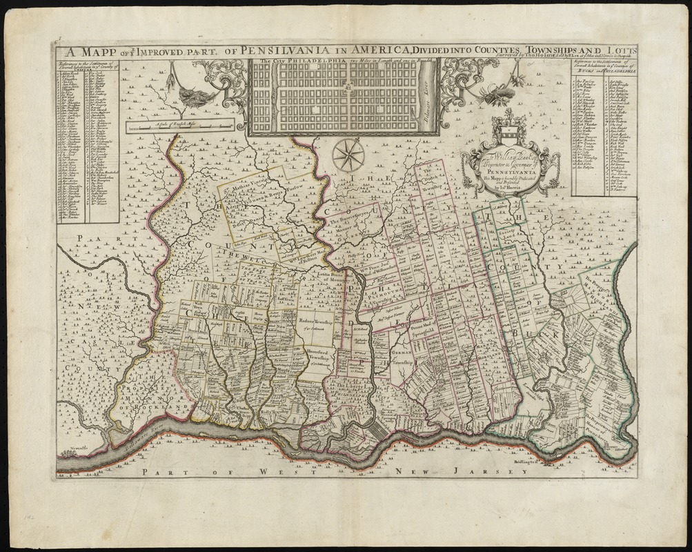
A mapp of ye improved part of Pensilvania in America, divided into countyes, townships, and lotts
Item Information
- Title:
- A mapp of ye improved part of Pensilvania in America, divided into countyes, townships, and lotts
- Title (alt.):
-
Collection of old maps
- Creator:
- Holme, Thomas, d. 1695
- Name on Item:
-
surveyed by Tho. Holme ; to William Penn Esq., proprietor & governer of Penn=sylvania, this mapp is humbly dedicated and presented by Ino. Harris.
- Date:
-
[1689?]
- Format:
-
Maps/Atlases
- Location:
-
Boston Public Library
Norman B. Leventhal Map Center - Collection (local):
-
Norman B. Leventhal Map Center Collection
- Subjects:
-
Real property--Pennsylvania--Maps--Early works to 1800
Real property--Pennsylvania--Philadelphia Region--Maps--Early works to 1800
Landowners--Pennsylvania--Maps--Early works to 1800
Landowners--Pennsylvania--Philadelphia Region--Maps--Early works to 1800
Pennsylvania--Maps--Early works to 1800
Pennsylvania--Administrative and political divisions--Maps--Early works to 1800
Philadelphia (Pa.)--Maps--Early works to 1800
- Places:
-
Philadelphia (county)Philadelphia
- Extent:
- 1 map : hand col. ; 40 x 55 cm.
- Terms of Use:
-
No known copyright restrictions.
No known restrictions on use.
- Publisher:
-
[London] :
Sold by P. Lea at ye Atlas and Hercules in Cheapside
- Scale:
-
Scale ca. 1:170,000
- Language:
-
English
- Notes:
-
Oriented with north toward the upper right.
Shows rural landholders' names and lots in Philadelphia, Chester, and Bucks Counties.
First issue.
Includes indexes of landholders and inset of "The city of Philadelphia, two miles in length and one in breadth," and coat of arms.
Cataloging, conservation, and digitization made possible in part by The National Endowment for the Humanities: Exploring the human endeavor.
Part of composite portfolio atlas with title "Collection of old maps."
- Identifier:
-
06_01_010218
- Call #:
-
G1015 .C651 1630
- Barcode:
-
30000003238059
- LCCN:
-
81692881

![[Environs of Philadelphia]](https://bpldcassets.blob.core.windows.net/derivatives/images/commonwealth:7h149x76d/image_thumbnail_300.jpg)

