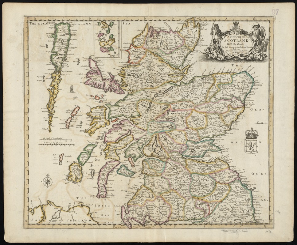
A new map of Scotland with the roads
Item Information
- Title:
- A new map of Scotland with the roads
- Creator:
- Greene, Robert, 1678?-1730
- Name on Item:
-
by Rob. Greene
- Date:
-
[1689]
- Format:
-
Maps/Atlases
- Location:
-
Boston Public Library
Norman B. Leventhal Map Center - Collection (local):
-
Norman B. Leventhal Map Center Collection
- Subjects:
-
Scotland--Maps--Early works to 1800
- Places:
-
Scotland
- Extent:
- 1 map : hand col. ; 46 x 52 cm.
- Terms of Use:
-
No known copyright restrictions.
No known restrictions on use.
- Publisher:
-
London :
Robert Greene at the Rose and Crown in Budg-row where you may have all sorts of mapps
- Scale:
-
Scale [ca. 1:847,500]
- Language:
-
English
- Notes:
-
Scale statement reads "A scale of Scotch Miles" 30 = 68 mm. ; "A scale of English Miles" 40 = 76 mm.
Relief shown pictorially.
Re-issue, and possible re-engraving of map previously issued by Greene with William Berry in 1679.
Features include compass rose ; roads ; yellow border surrounds map ; trees ; ship ; sea monster.
Ornate title cartouche with coat of arms.
Inset : "Orcades."
F. Lamb sculp.
Cataloging, conservation, and digitization made possible in part by The National Endowment for the Humanities: Exploring the human endeavor.
Part of composite portfolio atlas with title "Collection of old maps."
- Notes (date):
-
This date is inferred.
- Identifier:
-
06_01_010010
- Call #:
-
G1015 .C651 1630
- Barcode:
-
30000003115226


![Exactissima Regni Scotiae tabula tam in septentrionalem et meriodionalem quam in minores earundem provincias, insulasq[ue] ei undique praetensas accurate divisa](https://bpldcassets.blob.core.windows.net/derivatives/images/commonwealth:cj82kz35d/image_thumbnail_300.jpg)
