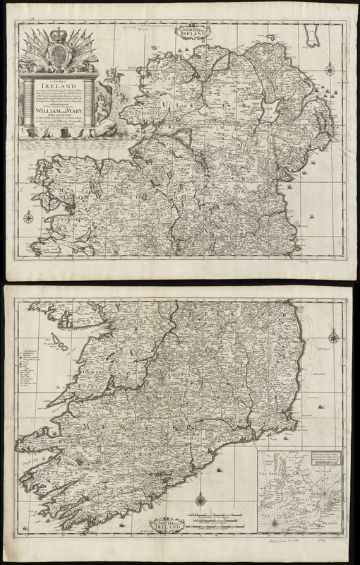
A new map of Ireland according to Sr. W. Petty (but supplied wth. many additions which are not in his survey nor in any other map) divided into its provinces, counties & barronies ... county maps
Item Information
- Title:
- A new map of Ireland according to Sr. W. Petty (but supplied wth. many additions which are not in his survey nor in any other map) divided into its provinces, counties & barronies ... county maps
- Title (alt.):
-
Collection of old maps
North part of Ireland
South part of Ireland
- Creator:
- Lea, Philip, fl. 1683-1700
- Date:
-
[1695]
- Format:
-
Maps/Atlases
- Location:
-
Boston Public Library
Norman B. Leventhal Map Center - Collection (local):
-
Norman B. Leventhal Map Center Collection
- Subjects:
-
Ireland--Maps--Early works to 1800
- Places:
-
Ireland
- Extent:
- 1 map on 2 sheets ; 95 x 61 cm, sheets 52 x 66 cm.
- Terms of Use:
-
No known copyright restrictions.
No known restrictions on use.
- Publisher:
-
London :
Sold by Philip Lea at the Atlas and Hercules in Cheapside
- Scale:
-
Scale [ca. 1:525,000]
- Language:
-
English
- Notes:
-
Relief shown pictorially.
Dedicated to King William and Queen Mary by P. Lea and H. Moll.
H. Moll fecit.
Inset: The sea coast of England, Scotland and Ireland also Holland and part of France.
Cataloging, conservation, and digitization made possible in part by The National Endowment for the Humanities: Exploring the human endeavor.
Part of composite portfolio atlas with title "Collection of old maps."
- Notes (date):
-
This date is inferred.
- Identifier:
-
06_01_010007
- Call #:
-
G1015 .C651 1630
- Barcode:
-
30000003115223


