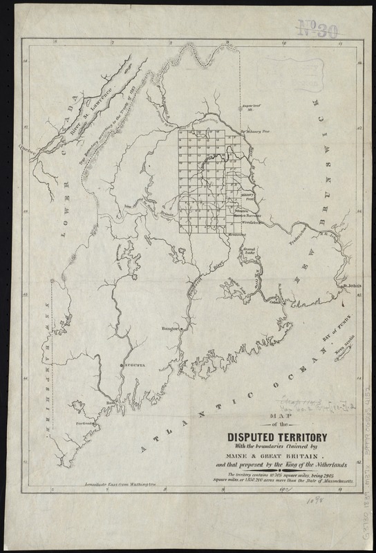
Map of the disputed territory with the boundaries claimed by Maine & Great Britain and that proposed by the King of the Netherlands
Item Information
- Title:
- Map of the disputed territory with the boundaries claimed by Maine & Great Britain and that proposed by the King of the Netherlands
- Date:
-
[1839?]
- Format:
-
Maps/Atlases
- Location:
-
Boston Public Library
Norman B. Leventhal Map Center - Collection (local):
-
Norman B. Leventhal Map Center Collection
- Subjects:
-
Aroostook War, 1839--Maps
Maine--Boundaries--New Brunswick--Maps
New Brunswick--Boundaries--Maine--Maps
United States--Boundaries--Canada--Maps
Canada--Boundaries--United States--Maps
- Places:
-
Maine
CanadaProvince of New Brunswick (province)
- Extent:
- 1 map ; 37 x 27 cm.
- Terms of Use:
-
No known copyright restrictions.
No known restrictions on use.
- Publisher:
-
S.l :
s.n
- Scale:
-
Scale [ca. 1:1,600,000]
- Language:
-
English
- Notes:
-
Relief shown by hachures.
Prime meridian: Washington.
"The territory contains 10.705 square miles being 2905 square miles or 1.850.200 acres more than the whole state of Massachusetts."
- Identifier:
-
06_01_008517
- Call #:
-
G3730 1839 .M37x
- Barcode:
-
39999065654152