Map of the United States
Item Information
- Title:
- Map of the United States
- Description:
-
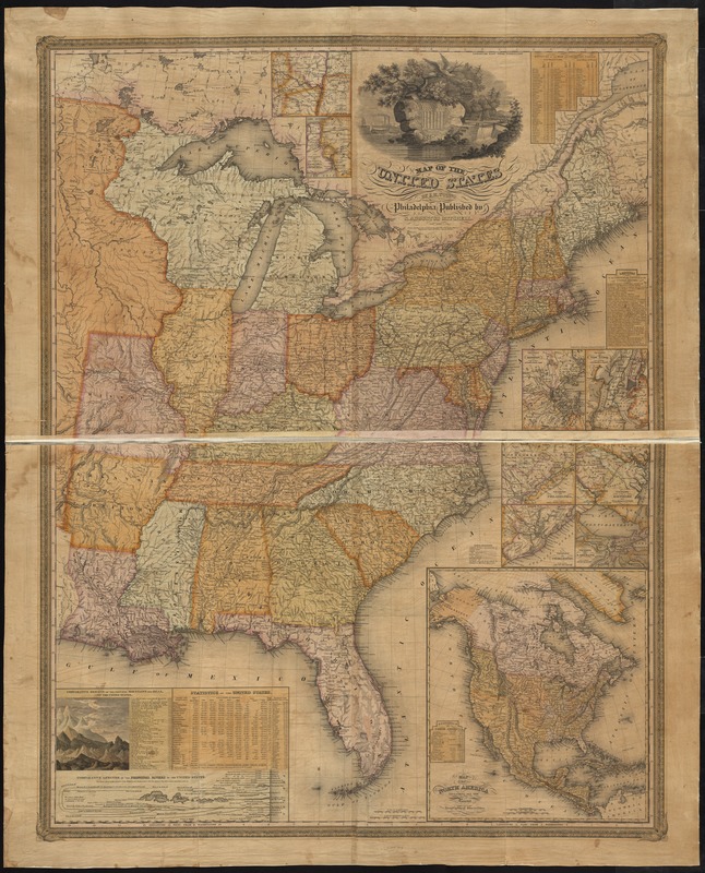
America Transformed: By 1831, the land east of the Mississippi had been divided into 24 states and the Michigan territory. In addition, American settlement and Native dispossession started to expand west of the Mississippi with the addition of Louisiana, Arkansas, and Missouri. The mapmakers also labeled the lands occupied by the Tsalagi (Cherokee), Mvskoke (Creek), Chikasha (Chickasaw), and Chahta (Choctaw) in large capital letters, although just a year earlier, the federal government had enacted the Indian Removal Act, which forced many tribes from their ancestral homelands. The law paved the way for the Trail of Tears, the name given to a series of forced relocations of these Native nations.
- Creator:
- Young, J. H. (James Hamilton)
- Name on Item:
-
by J.H. Young ; engraved by J. H. Young, D. Haines & E. Dankworth.
- Date:
-
[1831]
- Format:
-
Maps/Atlases
- Location:
-
Boston Public Library
Norman B. Leventhal Map Center - Collection (local):
-
Norman B. Leventhal Map Center Collection
- Subjects:
-
United States--Maps
- Places:
-
- Extent:
- 1 map : hand col. ; 107 x 84 cm.
- Terms of Use:
-
No known copyright restrictions.
No known restrictions on use.
- Publisher:
-
Philadelphia :
S. Augustus Mitchell
- Scale:
-
Scale [ca. 1:2,940,000]
- Language:
-
English
- Notes:
-
Relief shown by hachures.
Prime meridian: Washington.
Insets: Vicinity of Albany -- Vicinity of the falls of Niagara -- Vicinity of Boston -- Vicinity of New York -- Vicinity of Philadelphia -- Vicinity of Baltimore and Washington -- Vicinity of Charleston -- Vicinity of N. Orleans -- Map of North America includes all the recent geographical discoveries.
Includes statistics table, canal length and distance tables, and comparative height and length diagrams.
"Entered according to act of Congress... October 10th. 1831..."
- Notes (date):
-
This date is inferred.
- Notes (exhibitions):
-
Exhibited: "America transformed. Part 1: the United States expands westward," organized by the Norman B. Leventhal Map & Education Center at the Boston Public Library, 2019.
- Identifier:
-
06_01_008443
- Call #:
-
G3700 1831 .Y66
- Barcode:
-
39999065654806


