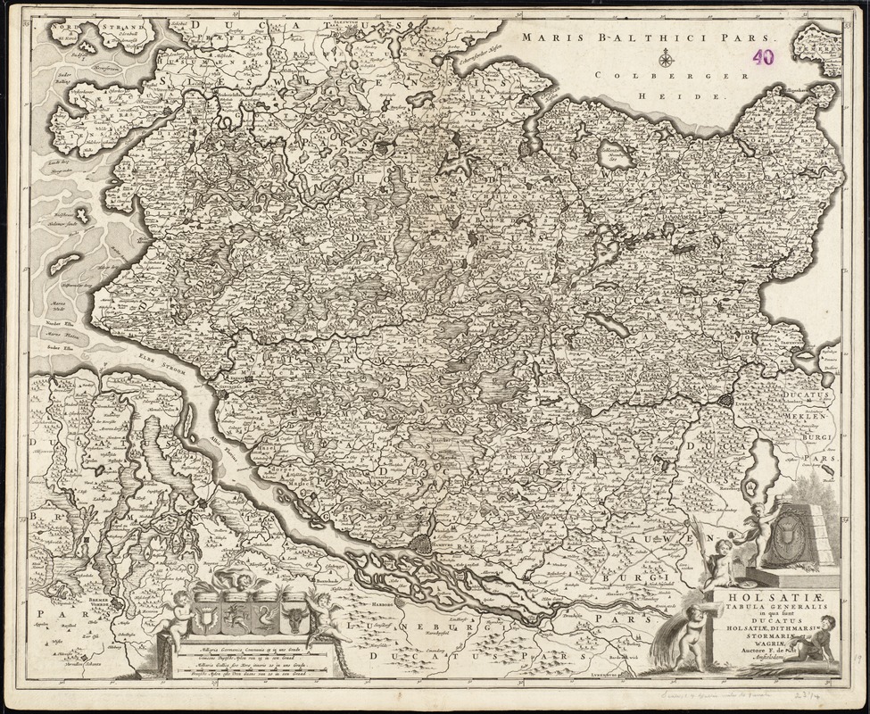
Holsatiae tabula generalis in qua sunt Ducatus Holsatiae, Dithmarsiae, Stormariae et Wagriae
Item Information
- Title:
- Holsatiae tabula generalis in qua sunt Ducatus Holsatiae, Dithmarsiae, Stormariae et Wagriae
- Title (alt.):
-
Collection of old maps
- Creator:
- Wit, Frederik de.
- Name on Item:
-
auctore F. de Wit.
- Date:
-
[1680?]
- Format:
-
Maps/Atlases
- Location:
-
Boston Public Library
Norman B. Leventhal Map Center - Collection (local):
-
Norman B. Leventhal Map Center Collection
- Subjects:
-
Schleswig-Holstein (Germany)--Maps--Early works to 1800
- Places:
-
Schleswig-Holstein
- Extent:
- 1 map ; 49 x 60 cm.
- Terms of Use:
-
No known copyright restrictions.
No known restrictions on use.
- Publisher:
-
Amstelodami :
[Frederik de Wit]
- Scale:
-
Scale [ca. 1:300,000]
- Language:
-
Latin
- Notes:
-
Map of the Schleswig-Holstein region in Germany.
Relief shown pictorially.
Prime meridian: Ferro.
Bar scale given in "milliaria Germanica communia" and "milliaria Gallica".
Appears in various editions of Wit's Atlas.
Text in Latin and Dutch.
Cataloging, conservation, and digitization made possible in part by The National Endowment for the Humanities: Exploring the human endeavor.
Part of composite portfolio atlas with title "Collection of old maps."
- Identifier:
-
06_01_008864
- Call #:
-
G1015 .C65 1630
- Barcode:
-
30000003834707