A new map of the world according to Wrights alias Mercators projection &c : drawn from the newest and the most exact observations together with a view of the general and coasting trade winds, monsoons or the shifting trade winds with other considerable improvements &c
Item Information
- Title:
- A new map of the world according to Wrights alias Mercators projection &c : drawn from the newest and the most exact observations together with a view of the general and coasting trade winds, monsoons or the shifting trade winds with other considerable improvements &c
- Title (alt.):
-
Collection of old maps
- Creator:
- Moll, Herman, d. 1732
- Name on Item:
-
by Ier: Seller and Cha: Price Hydrographers to the Queen at the Hermitage staires and at their shopp nex't the Fleece Taverne in Cornhill ; H: Moll fecit.
- Date:
-
[1706]
- Format:
-
Maps/Atlases
- Location:
-
Boston Public Library
Norman B. Leventhal Map Center - Collection (local):
-
Norman B. Leventhal Map Center Collection
- Subjects:
-
World maps
Navigation
1706
- Places:
-
World
- Extent:
- 1 map on 2 sheets : col. ; 53 x 93 cm, sheets 63 x 52 cm.
- Terms of Use:
-
No known copyright restrictions.
No known restrictions on use.
- Publisher:
-
London :
H. Moll
- Scale:
-
Scale [ca. 1:45,000,000] ;
- Language:
-
English
- Notes:
-
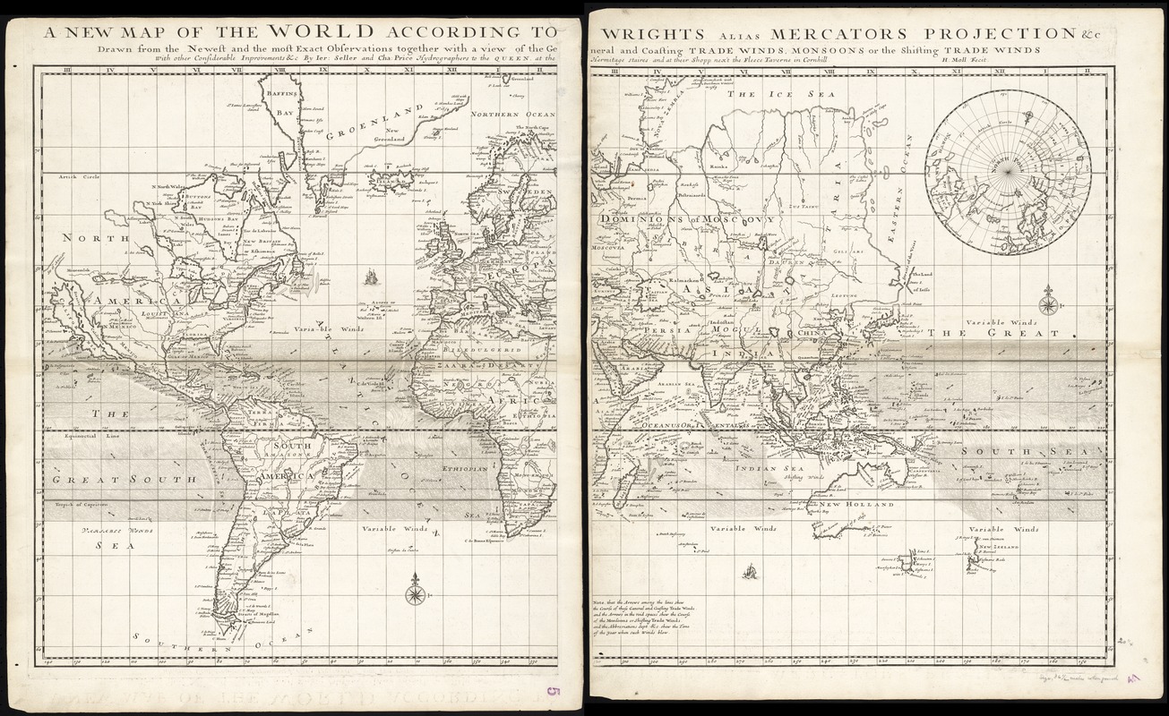
A detailed and large-scale world map, engraved by Herman Moll, with the imprints of Jeremiah Seller and Charles Price. The map is on Mercator's projection with arrows and shading through the middle depicting trade winds. Australia's coastline is incomplete, with the east coast, and a large section of the south coast not being drawn. Other areas of Australia not drawn are the north coast of Tasmania, and the area of Western Australia between Perth and Geraldton. Northern Queensland is connected to New Guinea on this map. Also, a large proportion of the coast of New Zealand is not drawn, and California is shown as an island.
In lower centre margin: Note, that the arrows among the lines shew the Course of those General and Coasting Trade Winds and the Arrows in the void spaces shew the Course of the Monsoons or Shifting Trade Winds and the Abbreviations Sept. & c. shew the Time of the year when such winds blow.
Sometimes bound into "Navigantium atque itinerantium bibliotheca ; Or, A complete collection of voyages and travels" by John Harris.
Inset: [North Polar view].
Cataloging, conservation, and digitization made possible in part by The National Endowment for the Humanities: Exploring the human endeavor.
Part of composite portfolio atlas with title "Collection of old maps."
- Notes (date):
-
This date is inferred.
- Identifier:
-
06_01_008688
- Call #:
-
G1015 .C65 1630
- Barcode:
-
30000003827752


