Linguistic families of American Indians north of Mexico
Item Information
- Title:
- Linguistic families of American Indians north of Mexico
- Description:
-
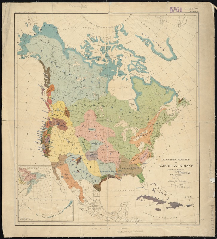
America Transformed: Originally displayed at Chicago's 1893 World Fair, this reconstructed map shows the distribution of major Indigenous language families at the time of European contact. Most maps published in the 1890s only depicted Indian reservations, but this map recognized that Native people originally controlled and inhabited all of North America. The map was compiled by John Wesley Powell, who studied the Colorado River, Grand Canyon, and local Native tribes during the 1870s while leading the Interior Department's Geographical and Geological Survey of the Rocky Mountain Region. Later, Powell became the first director of the Smithsonian Institution's Bureau of Ethnology, which archived government records relating to Native people and promoted anthropological research.
America Transformed: Viewpoint: The Native American Graves Protection and Repatriation Act legislates the return of Native Ancestors' remains and cultural items. However, anthropological maps such as this one can create ongoing obstacles. Scholars contend the Tongva (grouped into the outdated Shoshonean language family) moved to Southern California around 4,000 years ago. Some academic and cultural institutions will not return Ancestors to the Tongva that are older than this, stating they belong to tribes that predated the Tongva. Yet our oral traditions say we have always been here. Those are our Ancestors. We want them back. –Desiree R. Martinez, Tongva (Gabrielino), M.A. from Harvard University
- Creator:
- Powell, John Wesley, 1834-1902
- Name on Item:
-
by J.W. Powell.
- Date:
-
[1907?]
- Format:
-
Maps/Atlases
- Location:
-
Boston Public Library
Norman B. Leventhal Map Center - Collection (local):
-
Norman B. Leventhal Map Center Collection
- Subjects:
-
Indians of North America--Languages--Maps
North America--Maps
- Places:
-
North America (area)
- Extent:
- 1 map : col. ; 50 x 43 cm.
- Terms of Use:
-
No known copyright restrictions.
No known restrictions on use.
- Publisher:
-
N[ew] Y[ork] :
Julius Bien & Co., Lith.
- Scale:
-
Scale [ca. 1:15,400,000]
- Language:
-
English
- Notes:
-
From F.W. Hodge's Handbook of American Indians North of Mexico. Vol. 1. 1907. (Smithsonian Institution. Bureau of American Ethnology. Bullentin, no. 30)
Insets: N.E. Siberia -- Aleutian Islands.
- Notes (exhibitions):
-
Exhibited: "America Transformed. Part 2: Homesteads to Modern Cities," organized by the Norman B. Leventhal Map & Education Center at the Boston Public Library, 2019-2020.
- Identifier:
-
06_01_008429
- Call #:
-
G3301.E3 1907 .P69
- Barcode:
-
39999065653881


