Telegraph chart
Item Information
- Title:
- Telegraph chart
- Title on map :
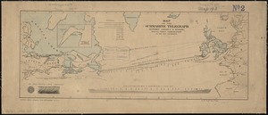
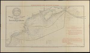
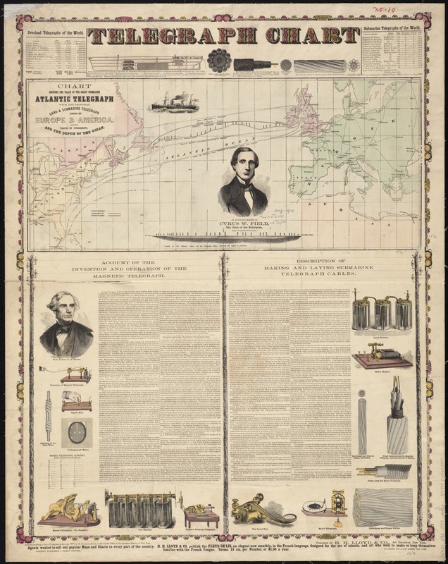
- Chart showing the track of the great submarine Atlantic telegraph : with the principal land & submarine telegraph lines in Europe & America, also, tracks of steamships, and the depth of the ocean
- Creator:
- H.H. Lloyd & Co
- Date:
-
1858
- Format:
-
Maps/Atlases
- Location:
-
Boston Public Library
Norman B. Leventhal Map Center - Collection (local):
-
Norman B. Leventhal Map Center Collection
- Subjects:
-
Transatlantic cables--Maps
Telegraph
Telegraph lines--North America--Maps
Telegraph lines--Europe--Maps
- Places:
-
Europe
North America (area)
Europe
- Extent:
- 1 map : hand col. ; 26 x 60 cm., on sheet 86 x 67 cm.
- Terms of Use:
-
No known copyright restrictions.
No known restrictions on use.
- Publisher:
-
New York :
H.H. Lloyd & Co.
- Scale:
-
Scale [ca. 1:18,500,000]
- Language:
-
English
- Notes:
-
Indicates land telegraph cables in the U.S., Canada, Great Britain, Europe, and north Africa, submarine cables, steamship routes, and proposed lines.
Depths shown by soundings.
Prime meridian: Greenwich.
Includes two double column articles of text: Account of the invention and operation of the magnetic telegraph -- Description of making and laying submarine telegraph cables.
Includes tables: Overland telegraphs of the world -- Submarine telegraphs of the world -- Morse's telegraphic alphabet.
Includes portraits of Cyrus W. Field and Samuel F.B. Morse, a cross section of the ship Niagara laying out the cable, illustrations of cables, telegraphs, signal keys and batteries, and a profile of the Atlantic Ocean on the telegraph plates.
"Entered according to Acot of Congress, in the year 1858, by H. H. Lloyd & Co."
- Identifier:
-
06_01_008392
- Call #:
-
G9101.P92 1858 .H45x
- Barcode:
-
39999065653451