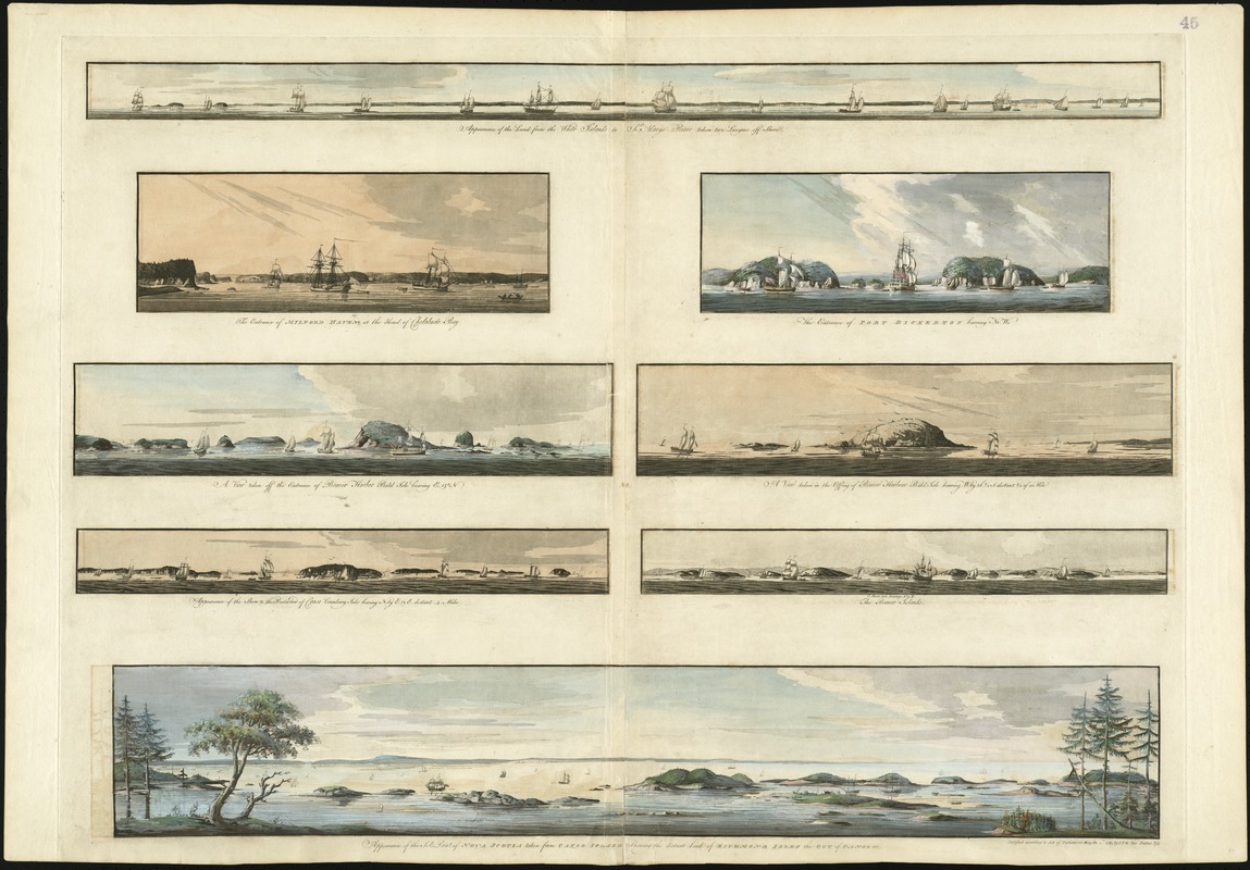
Appearance of the land from the White Islands to St. Marys River taken two leagues off shore : The entrance of Milford Haven at the head of Chedabucto Bay ; The entrance of Port Bickerton bearing N.W. ; A view taken off the entrance of Beaver Harbor Bald Isle bearing E. 15? N. ; A view taken in the offing of Beaver Harbor Bald Isle bearing W. by S. 3/4 S. distant 3/4 of a mile ; Appearance of the shore to the westward of Canso Cranberry Isle bearing N. by E. 1/2 E. distant 4 miles ; The Beaver Islands C. Bald Isle N. 1/2 E. ; Appearance of the S:E: point of Nova Scotia taken from Canso Island shewing the distant land of Richmond Isles the Gut of Canso &c
This map is also available in American Revolutionary Geographies Online (ARGO), a collections portal especially built for material relating to the American Revolutionary War Era. Visit ARGO to learn more about this item and explore the historical geography of North America in the late eighteenth century.
Item Information
- Title:
- Appearance of the land from the White Islands to St. Marys River taken two leagues off shore : The entrance of Milford Haven at the head of Chedabucto Bay ; The entrance of Port Bickerton bearing N.W. ; A view taken off the entrance of Beaver Harbor Bald Isle bearing E. 15? N. ; A view taken in the offing of Beaver Harbor Bald Isle bearing W. by S. 3/4 S. distant 3/4 of a mile ; Appearance of the shore to the westward of Canso Cranberry Isle bearing N. by E. 1/2 E. distant 4 miles ; The Beaver Islands C. Bald Isle N. 1/2 E. ; Appearance of the S:E: point of Nova Scotia taken from Canso Island shewing the distant land of Richmond Isles the Gut of Canso &c
- Title (alt.):
-
[Eight views of the east of Nova Scotia]
The entrance of Milford Haven at the head of Chedabucto Bay
The entrance of Port Bickerton bearing N.W
A view taken off the entrance of Beaver Harbor Bald Isle bearing E. 15? N
A view taken in the offing of Beaver Harbor Bald Isle bearing W. by S. 3/4 S. distant 3/4 of a mile
Appearance of the shore to the westward of Canso Cranberry Isle bearing N. by E. 1/2 E. distant 4 miles
The Beaver Islands C. Bald Isle N. 1/2 E
Appearance of the S:E: point of Nova Scotia taken from Canso Island shewing the distant land of Richmond Isles the Gut of Canso &c
- Description:
-
This grouping of eight headland views paints a striking picture of the Nova Scotia coast, east of Halifax. Covering a geographic area from Beaver Harbour northeast to Milford Haven (a distance of 160 miles), these coastal profiles served a utilitarian purpose for mariners navigating the complicated Nova Scotia coastline. Artistic elements such as foreboding skies and ships mooring in the port were added for aesthetic appeal; however, the coastal representations themselves were provided for navigational purposes. These views are a major advance over the earlier, unsophisticated headland views available to navigators in such works as the English Pilot.
- Creator:
- Des Barres, Joseph F. W. (Joseph Frederick Wallet), 1722-1824
- Date:
-
1781
- Format:
-
Maps/Atlases
- Location:
-
Boston Public Library
Norman B. Leventhal Map Center - Collection (local):
-
Norman B. Leventhal Map Center Collection
- Subjects:
-
Coasts--Nova Scotia--Pictorial works--Early works to 1800
Nova Scotia--Pictorial works--Early works to 1800
- Places:
-
CanadaNova Scotia (province)
- Extent:
- 8 views on 1 sheet : hand col. ; sheet 81 x 117 cm.
- Terms of Use:
-
No known copyright restrictions.
No known restrictions on use.
- Publisher:
-
[London] :
Published according to Act of Parliament J.F.W. Des Barres
- Scale:
-
Not drawn to scale.
- Language:
-
English
- Notes:
-
Eight coastal views of eastern Nova Scotia.
Appears in the author's Atlantic Neptune. London : J.F.W. Des Barres, 1777-[1781].
- Notes (exhibitions):
-
Exhibited: "Charting an Empire: The Atlantic Neptune" organized by the Norman B. Leventhal Map Center at the Boston Public Library, 2013.
Exhibited: "Crossing Boundaries: Art // Maps" organized by the Norman B. Leventhal Map & Education Center at the Boston Public Library, 2018-2019.
- Identifier:
-
06_01_008283
- Call #:
-
G1106.P5 D47 1777
- Barcode:
-
30000003797996


