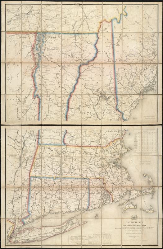
Post route map of the states of New Hampshire, Vermont, Massachusetts, Rhode Island, Connecticut, and parts of New York and Maine
Item Information
- Title:
- Post route map of the states of New Hampshire, Vermont, Massachusetts, Rhode Island, Connecticut, and parts of New York and Maine
- Title (alt.):
-
Post route map of the New England states
- Creator:
- Nicholson, Walter L.
- Name on Item:
-
designed and constructed under the orders of Postmaster General Wm. Dennison and Second Ass't Postmaster Gen'l Geo. Wm. McLellan, by W.L. Nicholson topographer of P.O. Dept.
- Date:
-
1872
- Format:
-
Maps/Atlases
- Location:
-
Boston Public Library
Norman B. Leventhal Map Center - Collection (local):
-
Norman B. Leventhal Map Center Collection
- Subjects:
-
Railroads--New England--Maps
Railroads--New York (State)--Maps
Railway mail service--New England--Maps
Postal service--United States--Maps
New England--Maps
New York (State)--Maps
Long Island (N.Y.)--Maps
- Places:
-
New York
- Extent:
- 1 map on 2 sheets : col. ; 149 x 96 cm, folded to 21 x 15 cm.
- Terms of Use:
-
No known copyright restrictions.
No known restrictions on use.
- Publisher:
-
Washington, D.C :
U.S. Post Office Dept.
- Scale:
-
Scale 1:380,160
- Language:
-
English
- Notes:
-
Longitude east from Washington, D.C.; latitude north from the equator. Also gives time differential for longitudes.
Boundaries of states and some postal routes in color.
First edition was issued in 1866.
"The service on this diagram brought up to date of Spt. 1st 1872."
Includes a table of distances and a table of general statistics for 1860 and 1866.
Railroad routes shown.
Drawn by P. Goepel and engraved by D. McClelland.
- Identifier:
-
06_01_007633
- Call #:
-
G3721.P8 1872 .N53x BOXED MAP
- Barcode:
-
39999065645747


