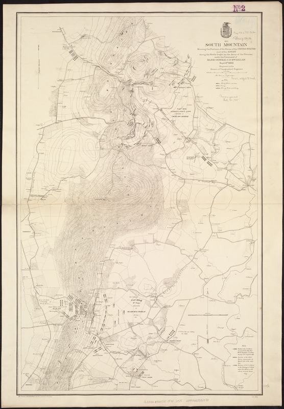
South Mountain showing the positions of the forces of the United States and the enemy during the battle fought by the Army of the Potomac under the command of Major General G. B. McClellan, Sept. 14th 1862
Item Information
- Title:
- South Mountain showing the positions of the forces of the United States and the enemy during the battle fought by the Army of the Potomac under the command of Major General G. B. McClellan, Sept. 14th 1862
- Creator:
- United States. Army. Corps of Topographical Engineers
- Name on Item:
-
Prepared in the Bureau of Topographical Engineers.
- Date:
-
1872
- Format:
-
Maps/Atlases
- Location:
-
Boston Public Library
Norman B. Leventhal Map Center - Collection (local):
-
Norman B. Leventhal Map Center Collection
- Subjects:
-
South Mountain, Battle of, Md., 1862--Maps
Burkittsville (Md.)--History--Civil War, 1861-1865--Maps
South Mountain (Pa. and Md.)--Maps
- Places:
-
Frederick (county)Burkittsville
South Mountain (area)
- Extent:
- 1 map, : col., ; 84 x 54 cm.
- Terms of Use:
-
No known copyright restrictions.
No known restrictions on use.
- Publisher:
-
S.l :
[s.n.]
- Scale:
-
Scale ca. 1:17,600.
- Language:
-
English
- Notes:
-
Detailed map giving the morning and evening positions of the Union troops and the morning position of the Confederate troops, roads, contour lines, drainage, vegetation, houses, names of residents, and fences.
Description derived from published bibliography.
- Identifier:
-
06_01_007456
- Call #:
-
G3844.B935S5 1872 .U55
- Barcode:
-
39999059031581
- LCCN:
-
99447402


