Map of the battlefield of Five-Forks
Item Information
- Title:
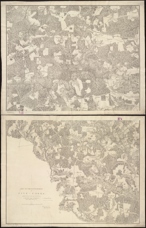
- Map of the battlefield of Five-Forks
- Creator:
- Michler, N. (Nathaniel), 1827-1881
- Name on Item:
-
compiled from surveys made under the direction of N. Michler, Major of Engineers, Brv't. Brig. Gen'l U.S.A. ; surveyed by Maj. J.E. Weyss, Theilkuhl, Burchard, Schumann, Thompson ; Drawn by F. Theilkuhl, Thompson, Schumann.
- Date:
-
[1865?]
- Format:
-
Maps/Atlases
- Location:
-
Boston Public Library
Norman B. Leventhal Map Center - Collection (local):
-
Norman B. Leventhal Map Center Collection
- Subjects:
-
Five Forks (Dinwiddie County, Va.)--History--19th century--Maps
- Places:
-
Dinwiddie (county)Five Forks
- Extent:
- 1 map on 2 sheets ; 112 x 72 cm, sheets 59 x 77 cm.
- Terms of Use:
-
No known copyright restrictions.
No known restrictions on use.
- Publisher:
-
S.l :
s.n.
- Scale:
-
Scale 1:15,840.
- Language:
-
English
- Notes:
-
Shows entrenchments, villages, roads, "South Side Rail Road," drainage, vegetation, relief by hachures, houses, and names of residents.
Description derived from published bibliography.
- Identifier:
-
06_01_007420
- Call #:
-
G3884.F475 1865 .M5
- Barcode:
-
39999059031169
- LCCN:
-
99439141


