Map of the siege of Vicksburg, Miss
Item Information
- Title:
- Map of the siege of Vicksburg, Miss
- Creator:
- Spangenberg, Charles.
- Name on Item:
-
by the U.S. forces under the command of Maj. Genl. U.S. Grant, U.S. Vls. Maj. F.E. Prime, Chief Engr. ; Surveyed and constructed under the direction of Capt. C.B. Comstock, U.S. Engrs. and Lt. Col. Js. H. Wilson, A.I. Genl., 1st Lt. Engrs., by Major Otto H. Matz, Ills. Vols., Chs. Spangenberg, Asst. Engr., Lts. Patton, Karnasch & Helmle, Mo. Vols., L. Zwanziger, S.R. Tresilian, B. Barth, S. Hartwell, Asst. Engs. ; Drawn by Chs. Spangenberg, Asst. Engr. ; Engr. on stone by J. Schedler, N.Y.
- Date:
-
[1863]
- Format:
-
Maps/Atlases
- Location:
-
Boston Public Library
Norman B. Leventhal Map Center - Collection (local):
-
Norman B. Leventhal Map Center Collection
- Subjects:
-
Vicksburg (Miss.)--History--Siege, 1863--Maps
- Places:
-
Warren (county)Vicksburg
- Extent:
- 1 map, col., 74 x 70 cm.
- Terms of Use:
-
No known copyright restrictions.
No known restrictions on use.
- Publisher:
-
S.l :
s.n.
- Scale:
-
Scale ca. 1:17,000 (not "1:15,840").
- Language:
-
English
- Notes:
-
Signed (facsim.): C.B. Comstock, Capt. of Engrs. Vicksburg, Miss. Head Qrs. of the Dept. of the Tenn. Aug. 20th 1863.
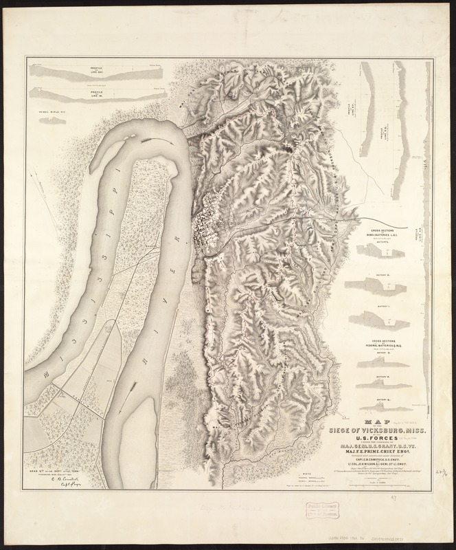
Detailed map showing entrenchments, roads, streets, railroads, hachures, vegetation, houses, and drainage.
Contains five topographic profiles, six cross sections of artillery batteries, and one cross section of a "rebel rifle pit."
Head Qrs. of the Dept. of the Tenn., Vicksburg, Miss., Aug. 20th, 1863.
Description derived from published bibliography.
- Notes (date):
-
This date is inferred.
- Identifier:
-
06_01_007405
- Call #:
-
G3984.V8S5 1863 .S6
- Barcode:
-
39999059030971
- LCCN:
-
99447212


