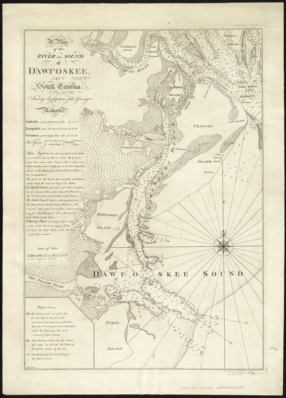
A plan of the river and sound of D'Awfoskee in South Carolina
This map is also available in American Revolutionary Geographies Online (ARGO), a collections portal especially built for material relating to the American Revolutionary War Era. Visit ARGO to learn more about this item and explore the historical geography of North America in the late eighteenth century.
Item Information
- Title:
- A plan of the river and sound of D'Awfoskee in South Carolina
- Creator:
- Gascoigne, John, d. 1753
- Name on Item:
-
Survey'd by John Gascoigne ; Batley, sculpt. ; [engraved by Jefferys and Faden].
- Date:
-
[1773?]
- Format:
-
Maps/Atlases
- Location:
-
Boston Public Library
Norman B. Leventhal Map Center - Collection (local):
-
Norman B. Leventhal Map Center Collection
- Subjects:
-
Nautical charts--South Carolina--Calibogue Sound--Early works to 1800
Nautical charts--South Carolina--Tybee Roads--Early works to 1800
Calibogue Sound (S.C.)--Maps--Early works to 1800
Sea Islands--Maps--Early works to 1800
Tybee Roads (S.C.)--Maps--Early works to 1800
- Places:
-
Beaufort (county)Calibogue Sound (bay)
Sea Islands (area)
Tybee Roads
- Extent:
- 1 map ; 65 x 46 cm.
- Terms of Use:
-
No known copyright restrictions.
No known restrictions on use.
- Publisher:
-
London :
s.n.
- Scale:
-
Scale ca. 1:63,360.
- Language:
-
English
- Notes:
-
Depths shown by soundings.
Described and dated 1776 in William P. Cumming's The Southeast in early maps. Dated 1773 in Essays honoring Lawrence C. Wroth.
Includes "Remarks" and "References."
Cataloging, conservation, and digitization made possible in part by The National Endowment for the Humanities: Exploring the human endeavor.
- Identifier:
-
06_01_007269
- Call #:
-
G3912.C32 1773 .G37
- Barcode:
-
39999059030500
- LCCN:
-
74692651


