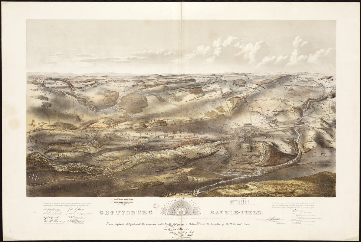
Gettysburg battle-field : Battle fought at Gettysburg, Pa., July 1st, 2d & 3d, 1863 by the Federal and Confederate armies, commanded respectively by Genl. G. G. Meade and Genl. Robert E. Lee
Item Information
- Title:
- Gettysburg battle-field : Battle fought at Gettysburg, Pa., July 1st, 2d & 3d, 1863 by the Federal and Confederate armies, commanded respectively by Genl. G. G. Meade and Genl. Robert E. Lee
- Description:
-
This bird’s-eye view of Gettysburg was one of the first and most attractive cartographic representations published after the battle. Despite its rapid production within less than a year after the engagement, its compilation was based on substantial research and provided a reportedly accurate portrayal of the military action and battleground. John Bachelder, a military instructor, historian, and artist before the war, was responsible for its compilation and publication. As hostilities began, he decided to follow the war in order to document its one decisive battle. He arrived at Gettysburg as the dead still lay on the ground. He spent 84 days traversing the battlefield, sketching its topography and interviewing convalescing Confederate soldiers, Union officers, and local residents in order to gather information for his meticulously-researched view.
- Creator:
- Bachelder, John B. (John Badger), 1825-1894
- Name on Item:
-
Jno. B. Bachelder, del. ; Endicott & Co., lith, N.Y.
- Date:
-
[ca. 1863]
- Format:
-
Maps/Atlases
- Location:
-
Boston Public Library
Rare Books Department - Collection (local):
-
Special Collections, Rare Books
- Subjects:
-
Gettysburg, Battle of, Gettysburg, Pa., 1863--Aerial views
Gettysburg Region (Pa.)--Aerial views
1863
- Places:
-
Adams (county)Gettysburg
- Extent:
- 1 view : hand col. ; 53 x 92 cm.
- Terms of Use:
-
No known copyright restrictions.
No known restrictions on use.
- Publisher:
-
Boston ; New York :
Jno. B. Bachelder
- Scale:
-
Scale not given.
- Language:
-
English
- Notes:
-
Inset: Plan of the Soldiers National Cemetery. Uncolored. 6 x 13 cm.
Bears a "Proof" mark in the lower left corner.
Endorsed (facsim.): I am perfectly satisfied with the accuracy with which the topography is delineated and the position of the troops laid down. [Signed] Geo. G. Meade, Maj. Gen. of Vols. comd. A. P.
The reproduced signatures of A. Doubleday, John Newton, Winf. St. Hancock, D.B. Birney, Geo. Sykes, John Sedgwick, O. O. Howard, A. S. Williams, and H. W. Slocum appear below the following statement: The positions of the troops of our respective commands represented upon this picture have been arranged under our immediate direction and may be relied upon as substantially corrct.
Colored bird's-eye view showing the topography of the battlefield by the perspective of the drawing, shading and coloring. Drainage, vegetation, roads and streets, railroads, bridges, houses and names of residents, fences, points of interest on the battlefield, including designations of places where officers were killed or wounded, are indicated.
The locations of the corps, divisions, brigades, etc. of both armies, with the names of commanding officers, are given in detail. Badge symbols are used to identify the Federal corps.
Description derived from published bibliography.
- Notes (exhibitions):
-
Exhibited: "Torn in Two: The 150th Anniversary of the Civil War" organized by the Norman B. Leventhal Map Center at the Boston Public Library, 2011.
- Identifier:
-
06_01_007156
- Call #:
-
BPL Rare Books Dept. 20th.Cab.2.3
- Barcode:
-
39999059030054
![[Panoramic view of the Gettysburg battlefield]](https://bpldcassets.blob.core.windows.net/derivatives/images/commonwealth:xg94j2023/image_thumbnail_300.jpg)