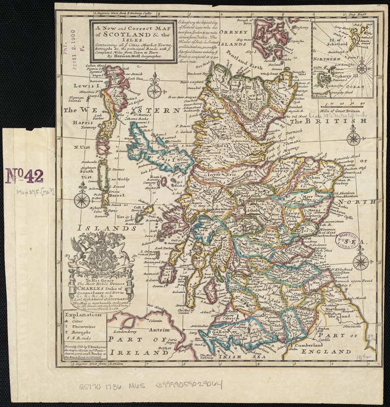
A new and correct map of Scotland and the Isles : containing all ye cities, market towns, boroughs &c., the principal roads, with ye computed miles from town to town
Item Information
- Title:
- A new and correct map of Scotland and the Isles : containing all ye cities, market towns, boroughs &c., the principal roads, with ye computed miles from town to town
- Creator:
- Moll, Herman, d. 1732
- Name on Item:
-
by Herman Moll, Geographer.
- Date:
-
[1736]
- Format:
-
Maps/Atlases
- Location:
-
Boston Public Library
Norman B. Leventhal Map Center - Collection (local):
-
Norman B. Leventhal Map Center Collection
- Subjects:
-
Roads--Scotland--Maps--Early works to 1800
Scotland--Maps--Early works to 1800
- Places:
-
Scotland
- Extent:
- 1 map : col. ; 29 x 27 cm.
- Terms of Use:
-
No known copyright restrictions.
No known restrictions on use.
- Publisher:
-
[London] :
Printed & sold by T. Bowles and I. Bowles
- Scale:
-
Scale [ca. 1:2,100,000]
- Language:
-
English
- Notes:
-
Relief shown pictorially.
Includes inset of Shetland and Orkney islands, ornamental cartouche with dedication to Prince Charles, Duke of Queensbury and Dover, and geographical note.
Prime meridians: Edinburgh Castle and London.
Appears in the author's Atlas minor. London : Thomas Bowles and John Bowles, [1736]
- Notes (date):
-
This date is inferred.
- Identifier:
-
06_01_007008
- Call #:
-
G5770 1736 .M65
- Barcode:
-
39999059029064


![Exactissima Regni Scotiae tabula tam in septentrionalem et meriodionalem quam in minores earundem provincias, insulasq[ue] ei undique praetensas accurate divisa](https://bpldcassets.blob.core.windows.net/derivatives/images/commonwealth:cj82kz35d/image_thumbnail_300.jpg)
