A humorous diplomatic atlas of Europe and Asia
Item Information
- Title:
- A humorous diplomatic atlas of Europe and Asia
- Description:
-
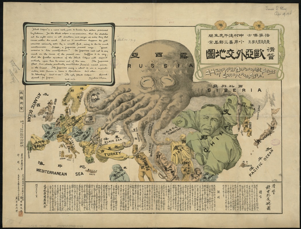
Created during the Russo-Japanese War (1904-1905) by a student at Keio University, this propaganda map presents a negative image of the Russian Empire. It is depicted as an over reaching “black octopus” extending its tentacles throughout Europe and Asia, with the other countries represented as human figures. Some countries like China thwart the attack, while others, including Persia and Tibet, are firmly in its grasp. Labeled in both Japanese and English, the map is definitely pro-Japanese. The author portrays Japan as a battle-ready soldier facing the octopus with a gun in one hand and a flag in the other.
- Creator:
- Ohara, Kisaburō.
- Date:
-
[1904]
- Format:
-
Maps/Atlases
- Location:
-
Boston Public Library
Norman B. Leventhal Map Center - Collection (local):
-
Norman B. Leventhal Map Center Collection
- Subjects:
-
Russo-Japanese War, 1904-1905--Maps
Caricature
Territorial expansion--Russia
Eurasia--Maps
- Places:
-
Eurasia (area)
Russia
- Extent:
- 1 map ; 33 x 54 cm.
- Terms of Use:
-
No known copyright restrictions.
No known restrictions on use.
- Publisher:
-
S.l :
s.n.
- Scale:
-
Scale not given.
- Language:
-
English
Japanese
- Notes:
-
Russia is represented as the "black octopus," stretching out in various directions after its prey.
Legend and explanatory text in Japanese and English.
- Notes (date):
-
This date is inferred.
- Notes (exhibitions):
-
Exhibited: "Unconventional Maps: Exploring the Stories of Cartographic Curiosities" organized by the Norman B. Leventhal Map Center at the Boston Public Library, 2011-2012.
- Identifier:
-
06_01_006602
- Call #:
-
G5690 1904 .O33
- Barcode:
-
39999059027043


