Map of routes for a Pacific railroad
Item Information
- Title:
- Map of routes for a Pacific railroad
- Description:
-
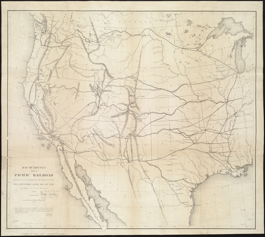
Sectional interest in controlling the West was particularly evident in the Pacific Railroad Surveys, conducted from 1853-54 under the direction of then Secretary of War, Jefferson Davis. Four east-west traverses, designed to satisfy both northern and southern sectional interests, were surveyed in order to determine the most practical route for the first trans-continental railroad. The potential routes were delineated on a “hurried“ map prepared by Lt. G.K. Warren in 1855, shortly after the surveys were completed. Although none of the four routes was selected in its entirety, the first trans-continental railroad followed a mid-continental route connecting Omaha and San Francisco. Begun during the war, this rail line was not completed until 1869, four years after the war ended.
- Creator:
- Warren, G. K. (Gouverneur Kemble), 1830-1882
- Name on Item:
-
compiled to accompany the report of the Hon. Jefferson Davis, Sec. of War in Office of P. R. R. Surveys ; G.K. Warren.
- Date:
-
1855
- Format:
-
Maps/Atlases
- Location:
-
Boston Public Library
Norman B. Leventhal Map Center - Collection (local):
-
Norman B. Leventhal Map Center Collection
- Subjects:
-
Railroads--West (U.S.)--Maps
Pacific railroads--Explorations and surveys--Maps
West (U.S.)--Maps
- Places:
-
Western United States (area)
- Extent:
- 1 map : hand col. ; 52 x 57 cm.
- Terms of Use:
-
No known copyright restrictions.
No known restrictions on use.
- Publisher:
-
[Washington, D.C.] :
Office of P. R. R. Surveys
- Scale:
-
Scale [ca. 1:6,000,000]
- Language:
-
English
- Notes:
-
Relief shown by hachures and spot heights.
Appears in the U.S. War Dept.'s Report of the Secretary of War on the several Pacific railroad explorations, 1855.
"This map is a hurried compilation of all the authentic surveys and is designed to exhibit the relations of the different routes to each other. An elaborate map on scale of 1:3,000,000 is being compiled and is in an advanced state."
- Notes (exhibitions):
-
Exhibited: "Torn in Two: The 150th Anniversary of the Civil War" organized by the Norman B. Leventhal Map Center at the Boston Public Library, 2011.
- Identifier:
-
06_01_006555
- Call #:
-
G4051.P3 1855 .W37
- Barcode:
-
39999059026516
- LCCN:
-
2007626788