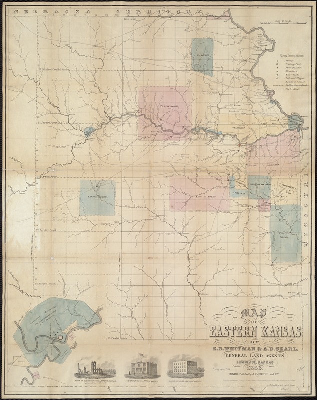
Map of Eastern Kansas
Item Information
- Title:
- Map of Eastern Kansas
- Cover title :
- Township map of Eastern Kansas
- Description:
-
The Kansas-Nebraska Act of 1854 established two new territories with a provision that settlers would decide whether they entered the Union as free or slave states. This legislation negated the 1820 Missouri Compromise which previously designated Missouri’s southern boundary as the dividing line between free and slave states. As eastern Kansas was settled during the 1850s, intense competition and armed conflict developed between pro-slavery and anti-slavery (Free State) factions, and the territory came to be known as “Bloody Kansas.“ Pro-slavery settlers moved from neighboring Missouri which permitted slavery, while groups such as the New England Emigrant Aid Company promoted anti-slavery settlement.
- Creator:
- Whitman, E. B. (Edmund Burke), 1812-1883
- Name on Item:
-
by E.B. Whitman & A.D. Searl.
- Date:
-
1856
- Format:
-
Maps/Atlases
- Location:
-
Boston Public Library
Norman B. Leventhal Map Center - Collection (local):
-
Norman B. Leventhal Map Center Collection
- Subjects:
-
Kansas--Maps
- Places:
-
Kansas
- Extent:
- 1 map : col. ; 67 x 52 cm.
- Terms of Use:
-
No known copyright restrictions.
No known restrictions on use.
- Publisher:
-
Boston :
J.P. Jewett and Co.
- Scale:
-
Scale [ca. 1:500,000]
- Language:
-
English
- Notes:
-
Shows towns, trading posts, forts, trails, and locations of Indian tribes.
"Entered according to act of Congress in the year 1856 by E.B. Whitman & A.D. Searl ...."
Includes ill. of notable buildings.
- Notes (exhibitions):
-
Exhibited: "Torn in Two: The 150th Anniversary of the Civil War" organized by the Norman B. Leventhal Map Center at the Boston Public Library, 2011.
- Identifier:
-
06_01_006559
- Call #:
-
G4200 1856 .W55
- Barcode:
-
39999059026557