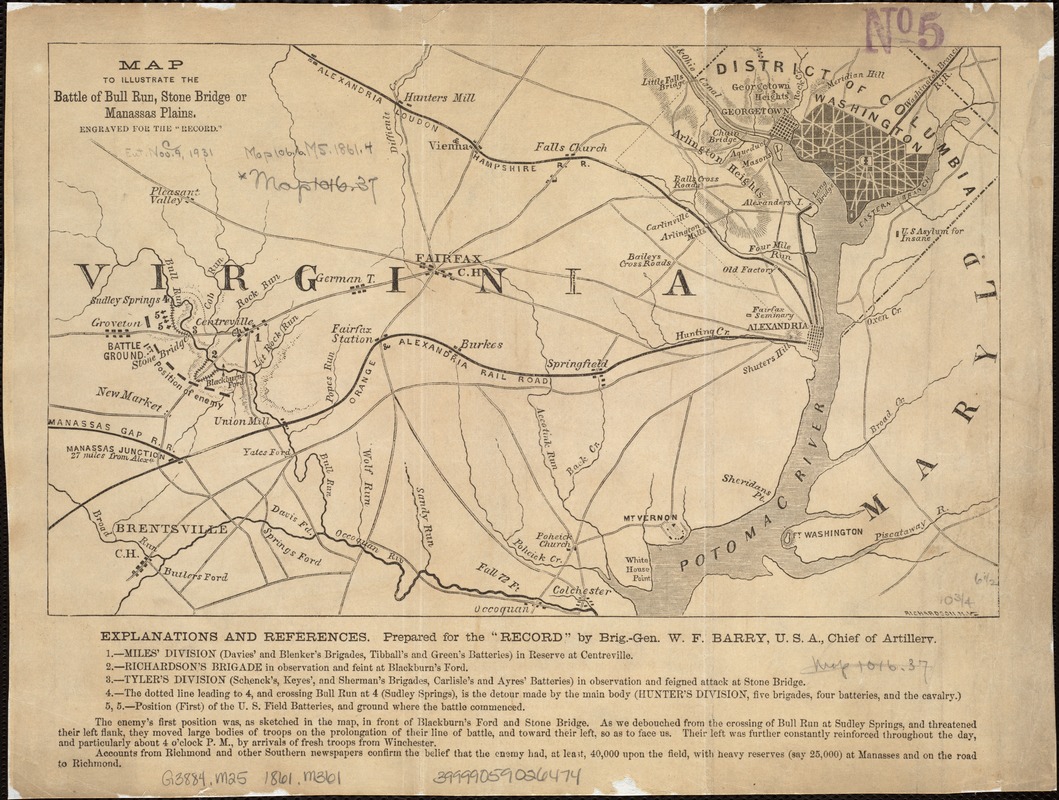
Map to illustrate the battle of Bull Run, Stone Bridge or Manassas Plains
Item Information
- Title:
- Map to illustrate the battle of Bull Run, Stone Bridge or Manassas Plains
- Description:
-
Torn in Two: This map, prepared by a Union artillery officer, focuses less on the battle action, but demonstrates its strategic significance in relation to Washington, DC. Charged with defending the nation’s capital, Union troops hoped to gain a quick victory over Confederate troops. Anticipating that a Union victory would bring a speedy end to the war, citizens from the nation’s capital came in carriages with picnic lunches to watch the action. Unfortunately, the poorly trained Union troops suffered a humiliating defeat, and both sides realized that the war would not be resolved quickly. Other names used for the battle, as reflected in the map’s title, were Stone Bridge and Manassas Plains. Another battle occurred in the same area, August 29-30, 1862, and subsequently was known as the Second Battle of Bull Run or Manassas.
- Name on Item:
-
engraved for the "Record.".
- Date:
-
[1862]
- Format:
-
Maps/Atlases
- Location:
-
Boston Public Library
Norman B. Leventhal Map Center - Collection (local):
-
Norman B. Leventhal Map Center Collection
- Subjects:
-
Bull Run, 1st Battle of, Va., 1861--Maps
United States--History--Civil War, 1861-1865--Campaigns--Maps
Virginia--History--Civil War, 1861-1865--Maps
- Places:
-
Manassas (independent city)
Prince William (county)Manassas National Battlefield Park (national park)
- Extent:
- 1 map ; 17 x 28 cm.
- Terms of Use:
-
No known copyright restrictions.
No known restrictions on use.
- Publisher:
-
New York :
G.P. Putnam
- Scale:
-
Scale not given.
- Language:
-
English
- Notes:
-
Relief shown by hachures.
Below map: Explanations and references prepared for the "Record" by Brig.-Gen. W.F. Barry, U.S.A. chief of artillery.
In lower right corner of map: Richardson, N.Y.
Map covers area from Washington to Groveton.
- Notes (date):
-
This date is inferred.
- Notes (exhibitions):
-
Exhibited: "Torn in Two: The 150th Anniversary of the Civil War" organized by the Norman B. Leventhal Map Center at the Boston Public Library, 2011.
- Identifier:
-
06_01_006550
- Call #:
-
G3884.M25 1861 .M361
- Barcode:
-
39999059026474