[Panoramic view of the Gettysburg battlefield]
![[Panoramic view of the Gettysburg battlefield]](https://bpldcassets.blob.core.windows.net/derivatives/images/commonwealth:xg94j2023/image_access_800.jpg)
Item Information
- Title:
- [Panoramic view of the Gettysburg battlefield]
- Description:
-
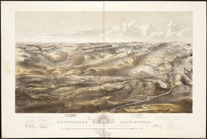
The three-day engagement that occurred at Gettysburg, July 1-3, 1863, is considered the turning point of the War. Our memory of the war’s most significant battle is reinforced by approximately 150 maps that have been published in the years following the conflict, far more than any other battle. One of the most unusual is this untitled and undated diagram that provides an unconventional fish-eye or 360-degree panoramic view of the battlefield. In the center of this circular, pictorial diagram is a numbered legend identifying 57 landmarks, locations of specific regiments, or sites of selected casualties.
- Date:
-
[1866?]
- Format:
-
Maps/Atlases
- Location:
-
Boston Public Library
Norman B. Leventhal Map Center - Collection (local):
-
Norman B. Leventhal Map Center Collection
- Subjects:
-
Gettysburg, Battle of, Gettysburg, Pa., 1863--Aerial views
Gettysburg (Pa.)--Aerial views
- Places:
-
Adams (county)Gettysburg
- Extent:
- 1 view ; 38 cm in diam., on sheet 41 x 40 cm.
- Terms of Use:
-
No known copyright restrictions.
No known restrictions on use.
- Publisher:
-
S.l :
s.n.
- Scale:
-
Not drawn to scale.
- Language:
-
English
- Notes:
-
360-degree panoramic view of the Gettysburg battlefield.
Includes numbered index to places of interest (1-57).
- Notes (exhibitions):
-
Exhibited: "Torn in Two: The 150th Anniversary of the Civil War" organized by the Norman B. Leventhal Map Center at the Boston Public Library, 2011.
- Identifier:
-
06_01_006528
- Call #:
-
G3822.G4A35 1866 .F57x
- Barcode:
-
39999059026359