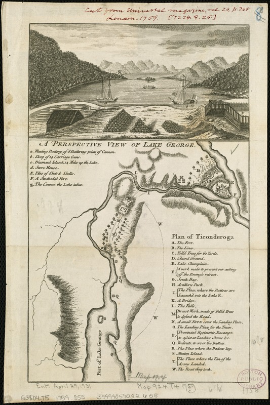
A perspective view of Lake George : Plan of Ticonderoga
This map is also available in American Revolutionary Geographies Online (ARGO), a collections portal especially built for material relating to the American Revolutionary War Era. Visit ARGO to learn more about this item and explore the historical geography of North America in the late eighteenth century.
Item Information
- Title:
- A perspective view of Lake George : Plan of Ticonderoga
- Creator:
- Skinner, H.
- Date:
-
[1759]
- Format:
-
Maps/Atlases
- Location:
-
Boston Public Library
Norman B. Leventhal Map Center - Collection (local):
-
Norman B. Leventhal Map Center Collection
- Subjects:
-
George, Lake (N.Y. : Lake)--Aerial views--Early works to 1800
Ticonderoga (N.Y.)--History--French and Indian War, 1754-1763--Maps
- Places:
-
George, Lake
Essex (county)Ticonderoga
- Extent:
- 1 view and 1 map on 1 sheet ; 9 x 16 cm. and 18 x 16 cm., sheet 30 x 21 cm.
- Terms of Use:
-
No known copyright restrictions.
No known restrictions on use.
- Publisher:
-
London :
J. Hinton
- Scale:
-
Scale not given.
- Language:
-
English
- Notes:
-
Relief shown by hachures on map.
Author attribution based on Phillips.
From Universal magazine, v. 25, Nov. 1759.
Includes keys to places of interest regarding the French and Indian War.
- Notes (date):
-
This date is inferred.
- Identifier:
-
06_01_006313
- Call #:
-
G3804.T5 1759 .S55
- Barcode:
-
39999059022655


