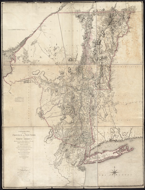
A chorographical map of the Province of New-York in North America, divided into counties, manors, patents and townships : exhibiting likewise all the private grants of land made and located in that Province
This map is also available in American Revolutionary Geographies Online (ARGO), a collections portal especially built for material relating to the American Revolutionary War Era. Visit ARGO to learn more about this item and explore the historical geography of North America in the late eighteenth century.
Item Information
- Title:
- A chorographical map of the Province of New-York in North America, divided into counties, manors, patents and townships : exhibiting likewise all the private grants of land made and located in that Province
- Creator:
- Sauthier, Claude Joseph.
- Name on Item:
-
compiled from actual surveys deposited in the Patent Office at New York, by order of His Excellency Major General William Tryon, by Claude Joseph Sauthier ; engraved and published by William Faden.
- Date:
-
1779
- Format:
-
Maps/Atlases
- Location:
-
Boston Public Library
Norman B. Leventhal Map Center - Collection (local):
-
Norman B. Leventhal Map Center Collection
- Subjects:
-
Real property--New York (State)--Maps--Early works to 1800
New York (State)--Maps--Early works to 1800
New York (State)--Administrative and political divisions--Maps--Early works to 1800
- Places:
-
New York
- Extent:
- 1 map on 3 sheets : col. ; 186 x 138 cm, sheets 62 x 41 cm.
- Terms of Use:
-
No known copyright restrictions.
No known restrictions on use.
- Publisher:
-
London :
Wm. Faden
- Scale:
-
Scale [ca. 1:326,000]
- Language:
-
English
- Notes:
-
Relief shown by hachures. Depths shown by form lines.
Hand colored.
Prime meridian: London.
Inscribed: To His Excellency Major General William Tryon ...
"Advertisement. The tracts of land coloured red, are military grants ... Those with a green edge are manors, and those coloured yellow are townships ... "
Appears in Thomas Jefferys' The American atlas. 1776.
Cataloging, conservation, and digitization made possible in part by The National Endowment for the Humanities: Exploring the human endeavor.
- Identifier:
-
06_01_006302
- Call #:
-
G3800 1779 .S28
- Barcode:
-
39999059022572


