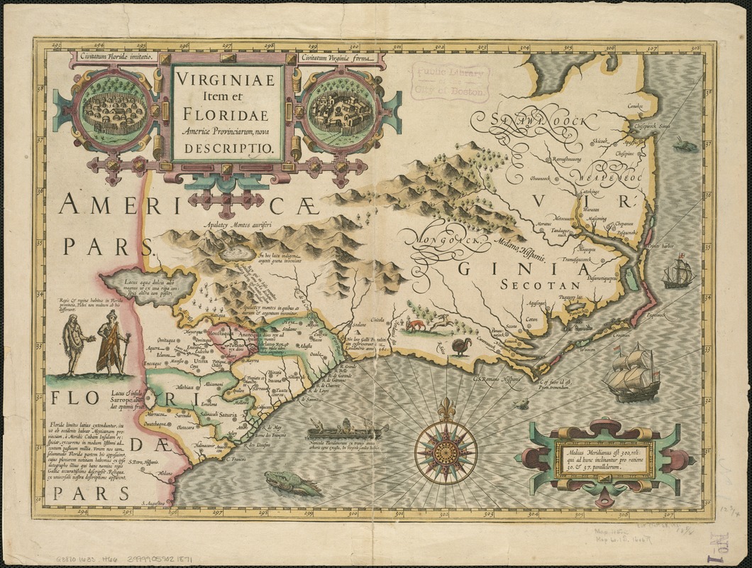
Virginiae item et Floridae Americae provinciarum, nova descriptio
Item Information
- Title:
- Virginiae item et Floridae Americae provinciarum, nova descriptio
- Creator:
- Hondius, Jodocus, 1563-1612
- Date:
-
[1633?]
- Format:
-
Maps/Atlases
- Location:
-
Boston Public Library
Norman B. Leventhal Map Center - Collection (local):
-
Norman B. Leventhal Map Center Collection
- Subjects:
-
South Atlantic States--Maps--Early works to 1800
Virginia--Maps--Early works to 1800
Florida--Maps--Early works to 1800
- Places:
-
Virginia
Florida
- Extent:
- 1 map : hand col. ; 33 x 47 cm.
- Terms of Use:
-
No known copyright restrictions.
No known restrictions on use.
- Publisher:
-
Amsterdam :
Hondius & Jansson
- Scale:
-
Scale [ca. 1:3,000,000]
- Language:
-
Latin
French
- Notes:
-
Relief shown pictorially.
Map by J. Hondius, from a French edition of Mercator's Atlas, probably 1633, with text on verso for "Virginie et la Floride," p. 697 and 700. Signature: Oooooooo, catchword: ayant.
Includes notes, col. ill., and cartouche with a view of a Florida Indian village on the left, and a Virginia Indian village on the right.
Text of the map in Latin; text on verso in French.
- Identifier:
-
06_01_006264
- Call #:
-
G3870 1633 .H66
- Barcode:
-
39999059021871
![Virginiae partis australis et Floridae partis orientalis, interjacentium[que] regionum nova descriptio](https://bpldcassets.blob.core.windows.net/derivatives/images/commonwealth:6t053p120/image_thumbnail_300.jpg)
![Virginiae partis australis, et Floridae partis orientalis, interjacentiumq[ue] regionum nova descriptio](https://bpldcassets.blob.core.windows.net/derivatives/images/commonwealth:st74cw930/image_thumbnail_300.jpg)