Map New England
Item Information
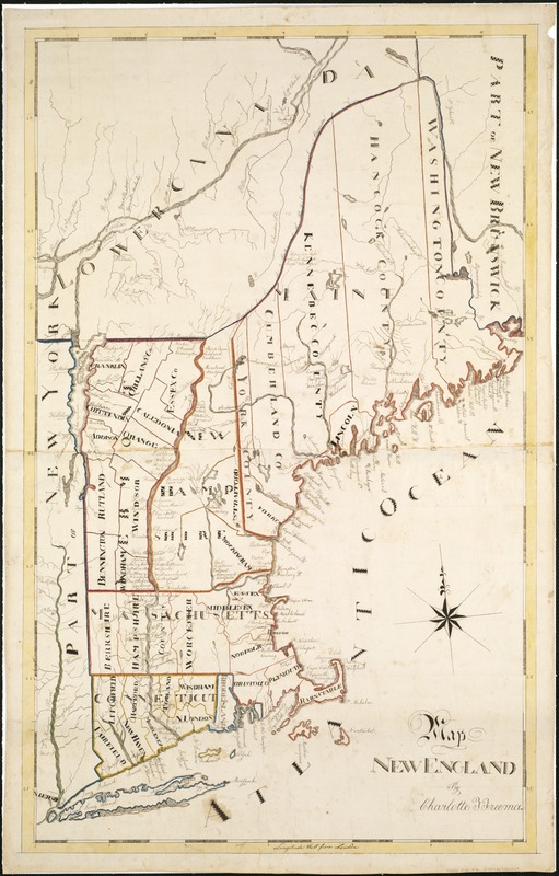
- Title:
- Map New England
- Title (alt.):
-
Map of New England
- Description:
-
Copying maps onto paper was a common assignment for both girls and boys attending academies in the 19th century, as students practiced geography and penmanship simultaneously. This map of New England details towns, counties and natural features such as rivers and lakes from Maine to Connecticut.
- Creator:
- Freeman, Charlotte F.
- Name on Item:
-
Charlotte F. Freeman.
- Date:
-
[1830]
- Format:
-
Maps/Atlases
Manuscripts
- Location:
-
Boston Public Library
Norman B. Leventhal Map Center - Collection (local):
-
Norman B. Leventhal Map Center Collection
- Subjects:
-
New England--Maps, Manuscript
- Places:
-
New England (area)
- Extent:
- 1 ms. map : col. ; 75 x 46 cm.
- Terms of Use:
-
No known copyright restrictions.
No known restrictions on use.
- Scale:
-
Scale not given.
- Language:
-
English
- Notes:
-
Shows the New England states with their counties delineated.
Norman B. Leventhal Map Center copy gift of Bank of America.
Manuscript "schoolgirl" map drawn by Charlotte F. Freeman, ca. 1830.
- Notes (date):
-
This date is inferred.
- Notes (exhibitions):
-
Exhibited: "Back to School: Geography in the Classroom" organized by the Norman B. Leventhal Map Center at the Boston Public Library, 2014-2015.
- Identifier:
-
06_01_006105
- Call #:
-
G3720 1830 .F7x
- Barcode:
-
39999059010049
![[Manuscript map of New England and eastern Canada, showing the routes of Champlain's voyage]](https://bpldcassets.blob.core.windows.net/derivatives/images/commonwealth:qb98n8061/image_thumbnail_300.jpg)


