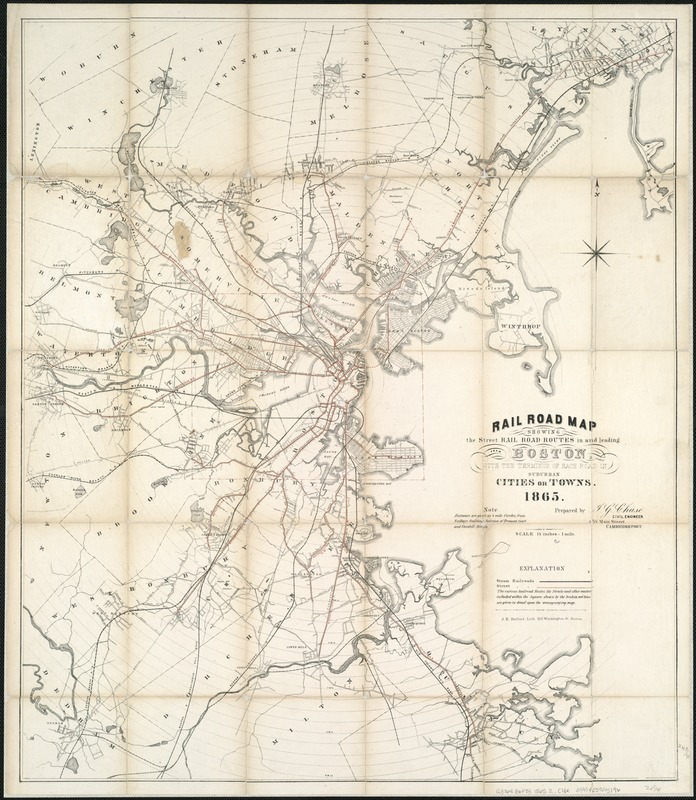
Rail road map : showing the street rail road routes in and leading from Boston, with the terminus of each road in suburban cities or towns
Item Information
- Title:
- Rail road map : showing the street rail road routes in and leading from Boston, with the terminus of each road in suburban cities or towns
- Title (alt.):
-
Railroad map showing the street rail road routes in and leading from Boston, with the terminus of each road in suburban cities or towns
- Creator:
- Chase, J. G.
- Name on Item:
-
prepared by J.G. Chase, civil engineer.
- Date:
-
1865
- Format:
-
Maps/Atlases
- Location:
-
Boston Public Library
Norman B. Leventhal Map Center - Collection (local):
-
Norman B. Leventhal Map Center Collection
- Subjects:
-
Street-railroads--Massachusetts--Boston--Maps
Street-railroads--Massachusetts--Boston Metropolitan Area--Maps
Boston (Mass.)--Maps
Boston Metropolitan Area (Mass.)--Maps
- Places:
-
Suffolk (county)Boston
- Extent:
- 1 map : col. ; 64 x 55 cm.
- Terms of Use:
-
No known copyright restrictions.
No known restrictions on use.
- Publisher:
-
Boston :
J.H. Bufford
- Scale:
-
Scale [1:42,240].
- Language:
-
English
- Notes:
-
Entered according to Act of Congress in the year 1865 by J.G. Chase in the Clerks Office of the District Court of the District of Mass.
Street railroads shown in red ink.
Shows radial distances from Scollay Building Junction.
- Identifier:
-
06_01_005903
- Call #:
-
G3764.B6P33 1865.2 .C4x
- Barcode:
-
39999059015196