Map of the town of Southbridge, Mass : including detail plans of Southbridge, Globe village and Sandersdale from recent and careful surveys under the supervision of the publishers
Item Information
- Title:
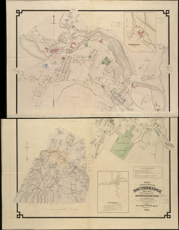
- Map of the town of Southbridge, Mass : including detail plans of Southbridge, Globe village and Sandersdale from recent and careful surveys under the supervision of the publishers
- Creator:
- New York Publishing House
- Date:
-
1878
- Format:
-
Maps/Atlases
- Location:
-
Boston Public Library
Norman B. Leventhal Map Center - Collection (local):
-
Norman B. Leventhal Map Center Collection
- Subjects:
-
Landowners--Massachusetts--Southbridge--Maps
Real property--Massachusetts--Southbridge--Maps
Southbridge (Mass.)--Maps
- Places:
-
Worcester (county)Southbridge
- Extent:
- 1 map on 2 sheets : hand co. ; 124 x 102 cm, sheets 62 x 102 cm.
- Terms of Use:
-
No known copyright restrictions.
No known restrictions on use.
- Publisher:
-
New York :
New York Publishing House
- Scale:
-
Scale [ca.1:19,200].
- Language:
-
English
- Notes:
-
Relief shown by hachures.
Shows names of streets, land owners, drainage, railroads, vegetation, schools, churches, and other points of interest.
Formerly a wall-map.
Inset: Sandersdale, Worcester Co. Mass (with text) -- Southbridge as it was in 1810.
Includes explanatory index.
- Identifier:
-
06_01_005465
- Call #:
-
G3764.S6G46 1878 .N4
- Barcode:
-
39999059014439


