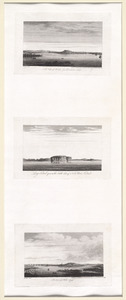
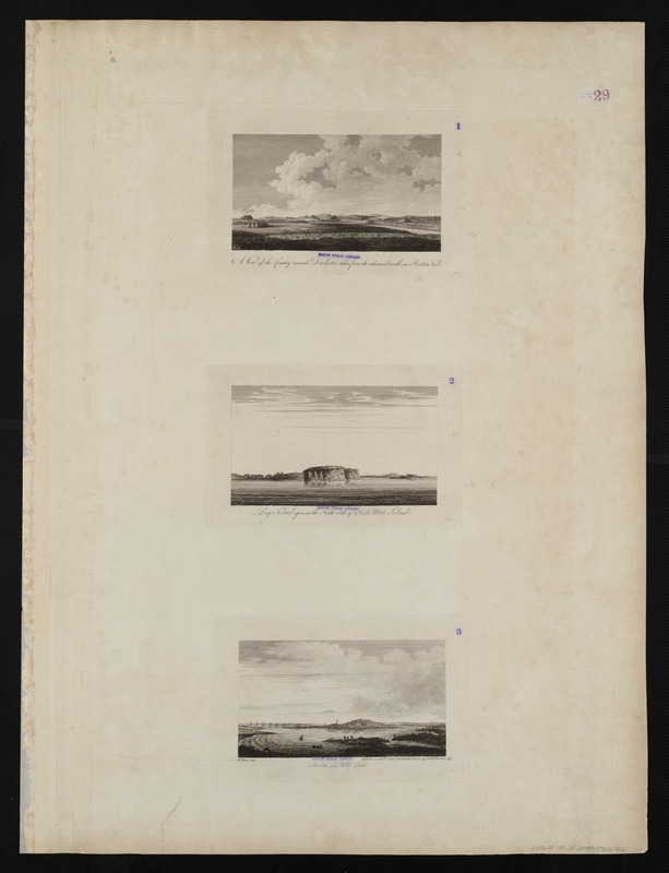
A view of the country towards Dorchester, taken from the advanced works on Boston Neck : Long Island open on the north side of Nicks Mate Island ; Boston from Willis Creek
This map is also available in American Revolutionary Geographies Online (ARGO), a collections portal especially built for material relating to the American Revolutionary War Era. Visit ARGO to learn more about this item and explore the historical geography of North America in the late eighteenth century.
Item Information
- Title:
- A view of the country towards Dorchester, taken from the advanced works on Boston Neck : Long Island open on the north side of Nicks Mate Island ; Boston from Willis Creek
- Title (alt.):
-
Long Island open on the north side of Nicks Mate Island
Boston from Willis Creek
- Creator:
- Des Barres, Joseph F. W. (Joseph Frederick Wallet), 1722-1824
- Date:
-
1775
- Format:
-
Maps/Atlases
- Location:
-
Boston Public Library
Norman B. Leventhal Map Center - Collection (local):
-
Norman B. Leventhal Map Center Collection
- Subjects:
-
United States--History--Revolution, 1775-1783--Pictorial works
Boston (Mass.)--Pictorial works--Early works to 1800
Long Island (N.Y.)--Pictorial works--Early works to 1800
- Places:
-
Suffolk (county)Boston
Long Island (island)
- Extent:
- 3 views on 1 sheet : etching ; each 12 x 21 cm, on sheet 82 x 62 cm.
- Terms of Use:
-
No known copyright restrictions.
No known restrictions on use.
- Publisher:
-
[London] :
J.F.W. Des Barres
- Scale:
-
Not drawn to scale.
- Language:
-
English
- Notes:
-
From the author's Atlantic Neptune.
- Identifier:
-
06_01_004515
- Call #:
-
G1106.P5 D47 1781
- Barcode:
-
30000003818436