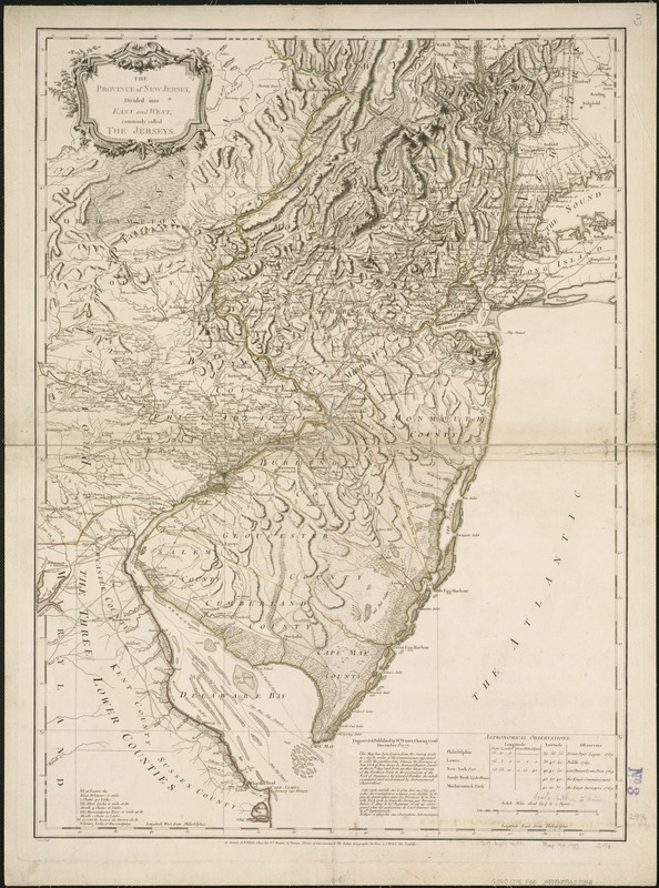
The province of New Jersey, divided into east and west, commonly called the Jerseys
This map is also available in American Revolutionary Geographies Online (ARGO), a collections portal especially built for material relating to the American Revolutionary War Era. Visit ARGO to learn more about this item and explore the historical geography of North America in the late eighteenth century.
Item Information
- Title:
- The province of New Jersey, divided into east and west, commonly called the Jerseys
- Creator:
- Faden, William, 1749-1836
- Date:
-
[1778]
- Format:
-
Maps/Atlases
- Location:
-
Boston Public Library
Norman B. Leventhal Map Center - Collection (local):
-
Norman B. Leventhal Map Center Collection
- Subjects:
-
New Jersey--Maps--Early works to 1800
New Jersey--Administrative and political divisions--Maps--Early works to 1800
- Places:
-
New Jersey
- Extent:
- 1 map : outline col. ; 75 x 56 cm.
- Terms of Use:
-
No known copyright restrictions.
No known restrictions on use.
- Publisher:
-
A Paris :
Chez les Srs. Perrier et Verrier, à l'Hotel de Soubise
- Scale:
-
Scale 1:430,000.
- Language:
-
English
- Notes:
-
Relief shown by hachures.
Notation at bottom: This map has been drawn from the survey made in 1769 ... by Bernard Ratzer.
Above notation: Engraved & published by Wm. Faden, Charing Cross, December 1st, 1777.
Imprint of Perrier et Verrier is below neat line at bottom.
French edition of state 1 of Faden's map.
Engraved by: Croisey.
Table of astronomical observations at lower right.
- Notes (date):
-
This date is inferred.
- Identifier:
-
06_01_004071
- Call #:
-
G3810 1778 .F33
- Barcode:
-
39999059022341


