The town of Boston in New England
Item Information
- Title:
- The town of Boston in New England
- Description:
-
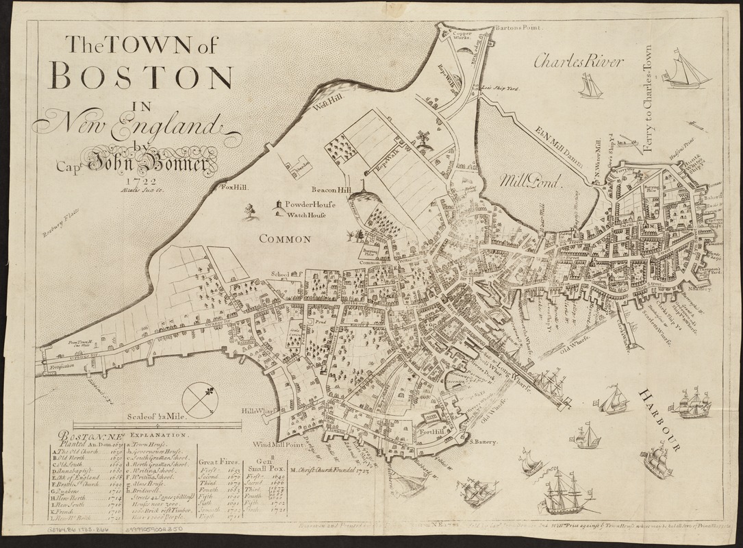
Made in Boston: Bonner's map depicts Boston before centuries of landfill transformed its coastline. His distinctive design combines plan and perspective views to convey maximum information and achieve decorative effect. It shows clearly the patterns of settlement, dense in the North End and along Cornhill and King Streets but thinning toward the south and west. The abundance of wharves, shipyards and ropewalks reflects Boston's flourishing maritime economy. Captain Bonner was more comfortable drawing sailing vessels than topography: the shipping in the harbor is carefully rendered, whereas simple bumps near the Common represent the "Trimontane" that once dominated the town. Beneath Our Feet: The city of Boston was settled by Europeans in 1630; however, the area had been home to Native Americans for thousands of years prior. This area, known as Shawmut to indigenous residents, was a peninsula that jutted out into Boston Harbor and was connected to the mainland by a thin strip called Boston Neck. This early 18th-century map illustrates the colonial "shape" of Boston nearly 100 years after Puritan colonists arrived, and depicts areas where Native objects were discovered during archaeological digs. Both the spear point and copper arrowhead displayed here were found in the Boston Common, while the fishweir stakes were found in nearby Back Bay.
- Creator:
- Bonner, John, ca. 1643-1726
- Name on Item:
-
by Capt. John Bonner.
- Date:
-
[1723–1733]
- Format:
-
Maps/Atlases
- Location:
-
Boston Public Library
Norman B. Leventhal Map Center - Collection (local):
-
Norman B. Leventhal Map Center Collection
- Subjects:
-
Boston (Mass.)--Maps--Early works to 1800
- Places:
-
Suffolk (county)Boston
- Extent:
- 1 map ; 43 x 59 cm.
- Terms of Use:
-
No known copyright restrictions.
No known restrictions on use.
- Publisher:
-
Boston, Mass :
Willm. Price
- Scale:
-
Scale [ca. 1:5,760].
- Language:
-
English
- Notes:
-
Oriented with north toward the upper right.
Index: A-M. a-h.
"Aetatis suae 80" under author's name.
"Engraven and printed by Fra. Dewing. Boston N.E. 1722 Sold by Capt. John Bonner and Willm. Price against ye Town House where may be had all sorts of prints, mapps &c."
Boston Public Library copy is an original, previously unrecorded state. Christ Church, fig. "M," is a unique addition to the index. Date of map is between 1723 and 1733.
- Notes (date):
-
This date is inferred.
- Notes (exhibitions):
-
Exhibited: "Made in Boston" organized by the Norman B. Leventhal Map Center at the Boston Public Library, 2013-2014.
Exhibited: "Beneath Our Feet: Mapping the World Below" organized by the Norman B. Leventhal Map Center at the Boston Public Library, 2017-2018.
- Identifier:
-
06_01_003817
- Call #:
-
G3764.B6 1723 .B66
- Barcode:
-
39999059002350


