[Fort Moultrie, Charlestown, South Carolina]
![[Fort Moultrie, Charlestown, South Carolina]](https://bpldcassets.blob.core.windows.net/derivatives/images/commonwealth:9s161d527/image_access_800.jpg)
Item Information
- Title:
- [Fort Moultrie, Charlestown, South Carolina]
- Title (alt.):
-
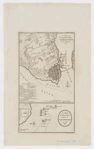
No. 1 Fort Sullivan afterwards called Fort Moultrie in the unfinished state it was on the 28th June 1776
No. 2 Sketch of a part of Sullivan's Island, the Fort, the Main, and the Shipping, during the Attack of the 28th June 1776
- Date:
-
[1876]
- Format:
-
Maps/Atlases
- Location:
-
Boston Public Library
Norman B. Leventhal Map Center - Collection (local):
-
Norman B. Leventhal Map Center Collection
- Subjects:
-
Fort Moultrie, Battle of, S.C., 1776--Maps
Fort Moultrie (S.C.)--Maps
- Places:
-
Charleston (county)Fort Moultrie
- Extent:
- 1 map ; 18 x 31 cm.
- Terms of Use:
-
No known copyright restrictions.
No known restrictions on use.
- Publisher:
-
S.l :
Council of Moultrieville
- Scale:
-
Scale not given.
- Language:
-
English
- Notes:
-
Facsimile.
Title supplied by cataloger.
Two views on one sheet: No. 1 Fort Sullivan afterwards called Fort Moultrie in the unfinished state it was on the 28th June 1776. the numbers opposite each cannon show the weight of ball they carried. Only part of the Fort which is shaded was finished. No. 2 Sketch of a part of Sullivan's Island, the Fort, the Main, and the Shipping, during the Attack of the 28th June 1776.
- Notes (date):
-
This date is inferred.
- Identifier:
-
06_01_003758
- Call #:
-
G3914.C3:2F5 1776 .F67 1876
- Barcode:
-
39999059001923