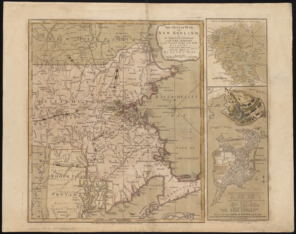
The seat of war in New England, by an American volunteer : with the marches of the several corps sent by the Colonies towards Boston, with the attack on Bunkers-Hill
This map is also available in American Revolutionary Geographies Online (ARGO), a collections portal especially built for material relating to the American Revolutionary War Era. Visit ARGO to learn more about this item and explore the historical geography of North America in the late eighteenth century.
Item Information
- Title:
- The seat of war in New England, by an American volunteer : with the marches of the several corps sent by the Colonies towards Boston, with the attack on Bunkers-Hill
- Title (alt.):
-
Plan of Boston Harbour, from an actual survey
Plan of the town of Boston with the attack on Bunkers-Hill in the peninsula of Charlestown, the 17th of June, 1775
- Date:
-
1775
- Format:
-
Maps/Atlases
- Location:
-
Boston Public Library
Norman B. Leventhal Map Center - Collection (local):
-
Norman B. Leventhal Map Center Collection
- Subjects:
-
Bunker Hill, Battle of, Boston, Mass., 1775--Maps--Early works to 1800
New England--History--Revolution, 1775-1783--Maps--Early works to 1800
Boston (Mass.)--Maps--Early works to 1800
Boston Harbor (Mass.)--Maps--Early works to 1800
- Places:
-
Boston Harbor
Suffolk (county)BostonBunker Hill
- Extent:
- 1 map : hand col. ; 44 x 38 cm.
- Terms of Use:
-
No known copyright restrictions.
No known restrictions on use.
- Publisher:
-
London :
Printed for R. Sayer & J. Bennett
- Scale:
-
Scale [ca. 1:450,000]
- Language:
-
English
- Notes:
-
Relief shown by hachures. Depths shown by soundings.
Prime meridians: Boston and London.
Includes "Plan of Boston Harbour, from an actual survey" and "Plan of the town of Boston with the attack on Bunkers-Hill in the peninsula of Charlestown, the 17th of June, 1775."
- Identifier:
-
06_01_003273
- Call #:
-
G3721.S3 1775 .S4
- Barcode:
-
39999059000008


