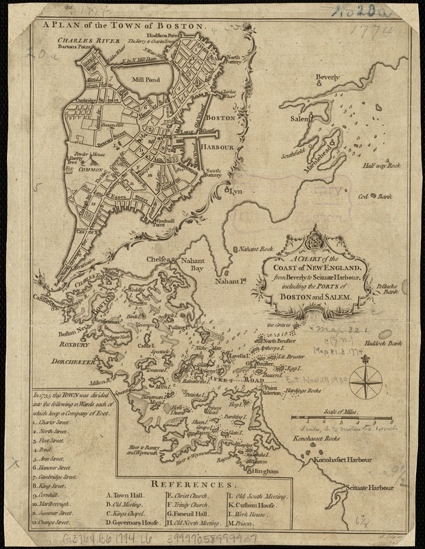
A chart of the coast of New England, from Beverly to Scituate harbour, including the ports of Boston and Salem
This map is also available in American Revolutionary Geographies Online (ARGO), a collections portal especially built for material relating to the American Revolutionary War Era. Visit ARGO to learn more about this item and explore the historical geography of North America in the late eighteenth century.
Item Information
- Title:
- A chart of the coast of New England, from Beverly to Scituate harbour, including the ports of Boston and Salem
- Title of inset map :
- Plan of the town of Boston
- Creator:
- Lodge, John, d. 1796
- Name on Item:
-
J. Lodge, sculp.
- Date:
-
[1774]
- Format:
-
Maps/Atlases
- Location:
-
Boston Public Library
Norman B. Leventhal Map Center - Collection (local):
-
Norman B. Leventhal Map Center Collection
- Subjects:
-
Coasts--Massachusetts--Maps--Early works to 1800
Boston (Mass.)--Maps--Early works to 1800
- Places:
-
Suffolk (county)Boston
- Extent:
- 1 map ; 25 x 18 cm.
- Terms of Use:
-
No known copyright restrictions.
No known restrictions on use.
- Publisher:
-
London :
[Massachusetts Historical Society?]
- Scale:
-
Scale [ca. 1:205,920].
- Language:
-
English
- Notes:
-
Depths shown by soundings.
From: The London magazine, or, Gentleman's monthly intelligencer, vol. 43, Apr. 1774.
Inset: A plan of the town of Boston.
Includes index to city wards and points of interest.
- Notes (date):
-
This date is inferred.
- Identifier:
-
06_01_003269
- Call #:
-
G3762.C6 1774 .L6
- Barcode:
-
39999058999937


![[Coast of New England from Chatham Harbor to Naragansett Bay]](https://bpldcassets.blob.core.windows.net/derivatives/images/commonwealth:7h149x27g/image_thumbnail_300.jpg)
![[Coast of New England from Chatham Harbor to Naragansett Bay]](https://bpldcassets.blob.core.windows.net/derivatives/images/commonwealth:7h149z37x/image_thumbnail_300.jpg)
