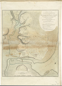
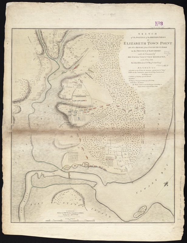
Sketch of the position of the British forces at Elizabeth Town Point after their return from Connecticut Farm, in the province of East Jersey : under the command of his excelly. Leiutt. Genl. Knyphausen, on the 8th June 1780
This map is also available in American Revolutionary Geographies Online (ARGO), a collections portal especially built for material relating to the American Revolutionary War Era. Visit ARGO to learn more about this item and explore the historical geography of North America in the late eighteenth century.
Item Information
- Title:
- Sketch of the position of the British forces at Elizabeth Town Point after their return from Connecticut Farm, in the province of East Jersey : under the command of his excelly. Leiutt. Genl. Knyphausen, on the 8th June 1780
- Creator:
- Hills, John, surveyor
- Name on Item:
-
by John Hills, lieut. 23d. Regt. & asst. engr.
- Date:
-
1784
- Format:
-
Maps/Atlases
- Location:
-
Boston Public Library
Norman B. Leventhal Map Center - Collection (local):
-
Norman B. Leventhal Map Center Collection
- Subjects:
-
Fortification--New Jersey--Maps--Early works to 1800
Elizabeth (N.J.)--History--18th century--Maps--Early works to 1800
Elizabeth (N.J.)--History--Revolution, 1775-1783--Maps--Early works to 1800
Springfield (Union County, N.J.)--History--18th century--Maps--Early works to 1800
- Places:
-
Union (county)Elizabeth
Union (county)Springfield
- Extent:
- 1 map : col. ; 61 x 51 cm.
- Terms of Use:
-
No known copyright restrictions.
No known restrictions on use.
- Publisher:
-
London :
Willm. Faden
- Scale:
-
Scale [ca. 1:13,000]
- Language:
-
English
- Notes:
-
Oriented with north to the upper right.
Relief shown by shading.
Shows fortifications, bridge of boats, and positions of individual British units during their retreat to Staten Island.
Table of references provides further information.
- Identifier:
-
06_01_003142
- Call #:
-
G3814.E5S3 1784 .H5
- Barcode:
-
39999058998855