Phelps & Ensign's travellers' guide, and map of the United States, containing the roads, distances, steam boat and canal routes &c
Item Information
- Title:
- Phelps & Ensign's travellers' guide, and map of the United States, containing the roads, distances, steam boat and canal routes &c
- Title (alt.):
-
Travellers' guide, and map of the United States
Phelps and Ensign's travellers' guide, and map of the United States
- Description:
-
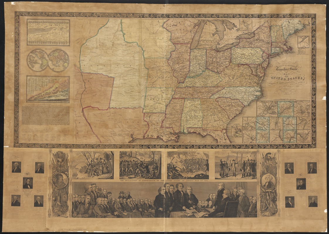
While intended as a traveler’s guide, this large wall map displays a number of patriotic illustrations. Historic moments such as the landing of the Pilgrims, the Battle of Bunker Hill, Washington’s farewell to his troops, and the signing of the Declaration of Independence are highlighted. The full text of this defining document and portraits of the nation’s first ten presidents are included. The map itself provides a snapshot of the nation 50 years after its founding, when the country consisted of 26 states and three territories.
- Creator:
- Phelps & Ensign
- Name on Item:
-
engraved on steel by J. Wells.
- Date:
-
1842
- Format:
-
Maps/Atlases
- Location:
-
Boston Public Library
Norman B. Leventhal Map Center - Collection (local):
-
Norman B. Leventhal Map Center Collection
- Subjects:
-
Transportation--United States--Maps
United States--Maps
United States--Distances, etc--Maps
- Places:
-
- Extent:
- 1 map : hand col. ; 40 x 93 cm. on sheet 73 x 103 cm.
- Terms of Use:
-
No known copyright restrictions.
No known restrictions on use.
- Publisher:
-
New York :
Published by Phelps & Ensign
- Scale:
-
Scale [ca. 1:4,750,000]
- Language:
-
English
- Notes:
-
Relief shown by hachures.
Prime meridian: Washington.
Distances from point to point shown on roads.
Map within decorative borders.
Contains numerous ill. and vignettes.
Submaps -- 1. A comparative view of the chief rivers in the world -- 2. The world -- 3. A comparative view of the principal mountains in the world -- 4. North part of Maine -- 5. South part of Florida -- 6. Vicinity of Baltimore -- 7. Vicinity of Charleston -- 8. Vicinity of New York -- 9. Vicinity of New Orleans -- 10. Vicinity of Pittsburg -- 11. Vicinity of Mobile -- 12. Vicinity of Chicago -- 13. Vicinity of Philadelphia -- 14. Vicinity of Cincinnati -- 15. Vicinity of Detroit -- 16. Vicinity of Boston -- 17. Vicinity of St. Louis -- 18. Vicinity of Washington.
- Notes (exhibitions):
-
Exhibited: "America Votes: Mapping the Political Landscape" organized by the Norman B. Leventhal Map Center at the Boston Public Library, 2012.
- Identifier:
-
06_01_003047
- Call #:
-
G3700 1842 .P5
- Barcode:
-
39999058997402


