Map of the metropolitan district of Boston, Massachusetts : showing the existing public reservations and such new open spaces as are proposed by Charles Eliot, Landscape Architect, in his report to the Metropolitan Park Commission
Item Information
- Title:
- Map of the metropolitan district of Boston, Massachusetts : showing the existing public reservations and such new open spaces as are proposed by Charles Eliot, Landscape Architect, in his report to the Metropolitan Park Commission
- Description:
-
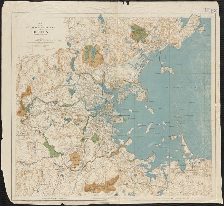
This 1893 map was included in Charles Eliot's report to the newly formed Metropolitan Park Commission (the forerunner of the DCR). The Commission was dedicated to preserving green spaces within a ten-mile radius of Boston. Due to a surging immigrant population and chaotic development in the late 19th Century, open space was disappearing at an alarming rate. As the Commission's first landscape architect, Eliot declared " …crowded populations, if they would live in health and happiness, must have space for air, for light, for exercise, for rest, and for the enjoyment of that peaceful beauty of nature …" This topographic map illustrates the open spaces he hoped to protect.
- Creator:
- Massachusetts. Metropolitan Park Commission
- Date:
-
1893
- Format:
-
Maps/Atlases
- Location:
-
Boston Public Library
Norman B. Leventhal Map Center - Collection (local):
-
Norman B. Leventhal Map Center Collection
- Subjects:
-
Recreation areas--Massachusetts--Boston--Maps
Open spaces--Massachusetts--Boston--Maps
Boston (Mass.)--Maps
Massachusetts--Maps
- Places:
-
Suffolk (county)Boston
- Extent:
- 1 map : col. ; 59 x 65 cm.
- Terms of Use:
-
No known copyright restrictions.
No known restrictions on use.
- Publisher:
-
Boston, Mass :
[Metropolitan Park Commission]
- Scale:
-
Scale 1:62,500
- Language:
-
English
- Notes:
-
Relief shown by contours.
"Contour interval 20 feet."
From: House No. 150, Report of the Board of Metropolitan Park Commissioners, January, 1893.
"Dated January 2d 1893."
- Notes (exhibitions):
-
Exhibited: "Breathing Room: Mapping Boston's Green Spaces" organized by the Norman B. Leventhal Map Center at the Boston Public Library, 2018.
Exhibited: "From the Sea to the Mountains: The Trustees 125th Anniversary" organized by the Norman B. Leventhal Map Center at the Boston Public Library, 2016.
- Identifier:
-
06_01_003031
- Call #:
-
G3764.B6E63 1893 .W3
- Barcode:
-
39999058997253


