The city of Boston
Item Information
- Title:
- The city of Boston
- Description:
-
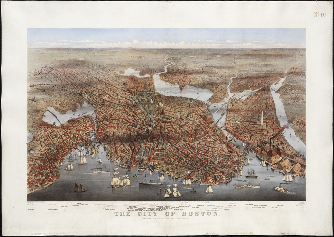
Published by the New York firm of Currier and Ives, this dramatic and colorful birds eye view observes the city from the northeast. It places the eastern waterfront with numerous ships, wharves, and warehouses in the foreground. A variety of important buildings and localities are identified in the lower margin, but are not clearly linked to specific buildings in the drawing. As is characteristic of Currier and Ives urban views, the buildings in the immediate foreground and center portions are shown in the greatest detail, while the upper half of the drawing is generalized and buildings only suggested as the city fades into the background. Without knowledge of the 1872 Harpers Weekly view, one would assume this to be a portrayal of the city as it existed in 1873, the year of publication. However, this view does not show any of the destruction resulting from the November 1872 fire. Granted the burned district was quickly rebuilt within one to two years, but in comparing the two images and considering the acknowledgements in the Harpers Weekly article, Parsons sketches of the city, from which the lithograph was derived, were apparently recorded before the fire. Charles R. Parsons and his father Charles Parsons, who became head of the art department at Harpers publishing firm in 1863, were involved in the production of approximately 40 urban views during the last half of the 19th century. Generally these views, and especially those drawn by the son, were published by Currier and Ives. This firm, which was noted for its production of popular American prints during the last half of the 19th century, was founded by Nathaniel Currier, a local figure, born and raised in the Roxbury suburb of Boston, and apprenticed with William and John Pendleton, who operated Bostons first lithography shop.
- Creator:
- Parsons & Atwater
- Name on Item:
-
Parsons & Atwater del.
- Date:
-
1873
- Format:
-
Maps/Atlases
- Location:
-
Boston Public Library
Norman B. Leventhal Map Center - Collection (local):
-
Norman B. Leventhal Map Center Collection
- Subjects:
-
Boston (Mass.)--Aerial views
- Places:
-
Suffolk (county)Boston
- Extent:
- 1 view : col. ; 52 x 83 cm.
- Terms of Use:
-
No known copyright restrictions.
No known restrictions on use.
- Publisher:
-
New York :
Currier & Ives
- Scale:
-
Not drawn to scale.
- Language:
-
English
- Notes:
-
Bird's-eye view.
Shows points of interest.
- Notes (exhibitions):
-
Exhibited: "Boston & Beyond: A Bird’s Eye View of New England" organized by the Norman B. Leventhal Map Center at the Boston Public Library, 2008.
Exhibited: "Unconventional Maps: Exploring the Stories of Cartographic Curiosities" organized by the Norman B. Leventhal Map Center at the Boston Public Library, 2011-2012.
- Identifier:
-
06_01_002600
- Call #:
-
G3764.B6A3 1873 .P3
- Barcode:
-
39999058996008
- LCCN:
-
75694553


