Ierusalem, et suburbia eius, sicut tempore Christi floruit c[um] locis, in quib[us] Christ[us] pass[us] est: que religiose a Christianis obseruata, etiam n[um] venerationi habent
![Ierusalem, et suburbia eius, sicut tempore Christi floruit c[um] locis, in quib[us] Christ[us] pass[us] est: que religiose a Christianis obseruata, etiam n[um] venerationi habent](https://bpldcassets.blob.core.windows.net/derivatives/images/commonwealth:2b88qf59p/image_access_800.jpg)
Item Information
- Title:
- Ierusalem, et suburbia eius, sicut tempore Christi floruit c[um] locis, in quib[us] Christ[us] pass[us] est: que religiose a Christianis obseruata, etiam n[um] venerationi habent
- Title (alt.):
-
Jerusalem, et suburbia eius, sicut tempore Christi floruit cum locis, in quibus Christus passus est: que religiose a Christianis obseruata, etiam num venerationi habent
- Description:
-
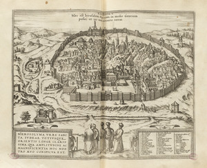
The final image of Jerusalem in Civitates Orbis Terrarum is the most dramatic. It appeared in the fourth volume on two pages, which are displayed here as a single sheet. Rather than a birds eye view, this depiction is more of a pictorial map, showing the facades of buildings placed adjacent to the streets and not drawn in perspective. As the extended title indicates, the map was compiled by Adrichem, a Dutch theologian and cartographer, to depict Jerusalem at the time of Christ. Adrichems map was originally published in 1584, but Braun and Hogenberg republished it with little change, except for the orientation. The original map, with a horizontal format, was oriented with west at top. In the Civitates, the map was rotated to a vertical format, placing north at the top. The map presents an imaginary conception of the city, with many buildings depicted as 16th century European structures. In addition there are 270 numbered and captioned scenes, showing sites or events mentioned in the Bible and other historical sources. Some date back to Kings David and Solomon, but many record events surrounding the life and crucifixion of Jesus.
- Creator:
- Adrichem, Christiaan van, 1533-1585
- Name on Item:
-
descripta per Christianum Adrichom Delphum.
- Date:
-
[1584–1588]
- Format:
-
Maps/Atlases
- Location:
-
Boston Public Library
Norman B. Leventhal Map Center - Collection (local):
-
Norman B. Leventhal Map Center Collection
- Subjects:
-
Pictorial maps--Early works to 1800
Jerusalem--Maps--Early works to 1800
- Places:
-
Jerusalem (territory)Jerusalem
- Extent:
- 1 map : col. ; 72 x 48 cm.
- Terms of Use:
-
No known copyright restrictions.
No known restrictions on use.
- Publisher:
-
Köln :
G. Braun and F. Hogenberg
- Scale:
-
Scale not given.
- Language:
-
Latin
- Notes:
-
Map contains sites and scenes of Jerusalem, both within and outside the city, identified by two hundred and seventy captions - each depicting an item mentioned in the Scriptures, and other historical and traditional sources. There is no chronological order to the scenes, as ancient scenes and characters are displayed alongside European buildings and characters of the sixteenth century.
Appears in Braun and Hogenberg's Civitates Orbis Terrarum. Koln. [1588?].
- Notes (date):
-
This date is inferred.
- Notes (exhibitions):
-
Exhibited: "Boston & Beyond: A Bird’s Eye View of New England" organized by the Norman B. Leventhal Map Center at the Boston Public Library, 2008.
Exhibited: "Unconventional Maps: Exploring the Stories of Cartographic Curiosities" organized by the Norman B. Leventhal Map Center at the Boston Public Library, 2011-2012.
- Identifier:
-
06_01_000903
- Call #:
-
G7504.J4A5 1584 .A37
- Barcode:
-
39999058989110