Boston Harbour in New England
Item Information
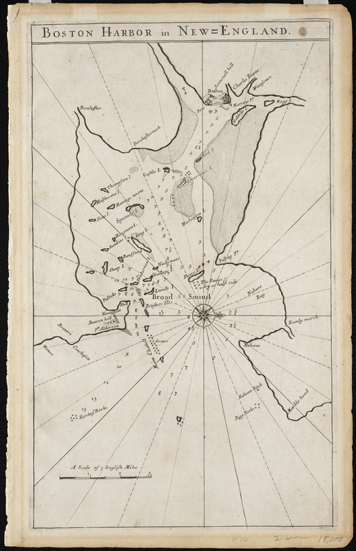
- Title:
- Boston Harbour in New England
- Description:
-
This is the first printed chart of Boston Harbor. It appeared only in the 1689 and 1698 editions of The English Pilot, The Fourth Book. Seller's publication became the most popular navigational manual for ships sailing to the New World during the 18th century. It was constantly updated with 37 editions appearing between 1689 and 1794. This rather simple diagram of the harbor was quickly replaced with a chart based on a new and more detailed survey of the harbor and bay. The new chart appeared in various editions of The English Pilot published by Mount and Page from approximately 1707 to 1732.
- Creator:
- Seller, John, fl. 1658-1698
- Contributor:
- Southack, Cyprian, 1662-1745
- Date:
-
[1689]
- Format:
-
Maps/Atlases
- Location:
- Private Collection
- Collection (local):
-
Mapping Boston Collection
- Subjects:
-
Nautical charts--Massachusetts--Boston Harbor--Early works to 1800
Boston Harbor (Mass.)--Maps--Early works to 1800
- Places:
-
Boston Harbor
- Extent:
- 1 chart ; 41 x 25 cm.
- Terms of Use:
-
No known copyright restrictions.
This work is licensed for use under a Creative Commons Attribution Non-Commercial Share Alike License (CC BY-NC-SA).

- Publisher:
-
London :
Seller
- Scale:
-
Scale not given
- Language:
-
English
- Notes:
-
Oriented with north to the right.
Depths shown by soundings.
Relief shown pictorially.
- Notes (date):
-
This date is inferred.
- Notes (exhibitions):
-
Exhibited: "Made in Boston" organized by the Norman B. Leventhal Map Center at the Boston Public Library, 2013-2014.
- Identifier:
-
06_01_001151
- Barcode:
-
39999052508676


