Map of parts of Boston Harbor and its tributaries
Item Information
- Title:
- Map of parts of Boston Harbor and its tributaries
- Description:
-
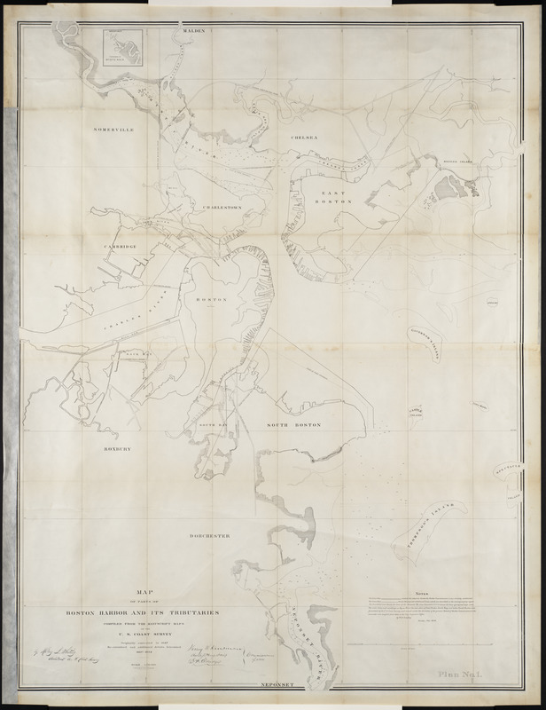
Compiled from manuscript maps prepared by the U.S. Coast Survey in 1847 and updated to 1854, this was one of four maps that accompanied the first report of the Commissioners on Boston Harbor and the Back Bay. The other maps provided larger scale representations of Mystic River, South Bay, the Neponset River and parts of Dorchester Bay. One of the key features of these maps was the delineation of harbor commissioners' lines as defined for 1847, with proposed revisions for 1854. These lines defined how far wharves could extend from the shore, thus helping to define the city's expanding shoreline.
- Creator:
- United States Coast Survey
- Contributor:
- L.H. Bradford & Co
- Name on Item:
-
compiled from the manuscript maps of the U.S. Coast Survey
- Date:
-
1854
- Format:
-
Maps/Atlases
- Location:
- Private Collection
- Collection (local):
-
Mapping Boston Collection
- Subjects:
-
Boston Harbor (Mass.)--Maps
- Places:
-
Boston Harbor
- Extent:
- 1 plan ; 136 x 103 cm.
- Terms of Use:
-
No known copyright restrictions.
This work is licensed for use under a Creative Commons Attribution Non-Commercial Share Alike License (CC BY-NC-SA).

- Publisher:
-
Boston :
[U.S. Coast Survey Office]
- Scale:
-
Scale 1:10,000
- Language:
-
English
- Notes:
-
Originally executed in 1847. Re-examined and additional details determined Sept. 1854.
Depths shown by soundings.
- Identifier:
-
06_01_001249
- Barcode:
-
39999052508510


