New England : the most remarqueable parts thus named by the high and mighty Prince Charles, prince of great Britaine
Item Information
- Title:
- New England : the most remarqueable parts thus named by the high and mighty Prince Charles, prince of great Britaine
- Description:
-
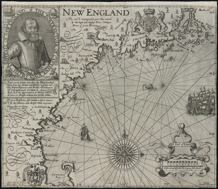
Based on John Smith's 1614 voyage along the New England coast, this is the first printed map devoted specifically to this region. It is also the first to use the name “New England” for an area that had up until this time been called “North Virginia.” Smith, who is more commonly associated with the founding of Virginia, was commissioned to survey the coastline north of New York in preparation for the settlement of another English colony. This map was used to guide the Pilgrims to Plymouth and also led John Winthrop to the Charles River in 1629.
- Creator:
- Smith, John, 1580-1631
- Name on Item:
-
observed and described by Captayn John Smith, 1614 ; Simon Pas[?]us, sculpsit. ; Robert Cler[?], excudit.
- Date:
-
[1624]
- Format:
-
Maps/Atlases
- Location:
- Private Collection
- Collection (local):
-
Mapping Boston Collection
- Subjects:
-
Maps
New England--Maps--Early works to 1800
Atlantic Coast (New England)--Maps--Early works to 1800
- Places:
-
New England (area)
- Extent:
- 1 map ; 30 x 36 cm.
- Terms of Use:
-
No known copyright restrictions.
This work is licensed for use under a Creative Commons Attribution Non-Commercial Share Alike License (CC BY-NC-SA).

- Publisher:
-
London :
Printed by Geor. Low
- Scale:
-
Scale [ca. 1:1,120,000]
- Language:
-
English
- Notes:
-
Relief shown pictorially.
From Smith's The General Historie of Virginia, New-England, and the Summer Isles. London. 1624.
Includes ill.
State 4.
- Notes (date):
-
This date is inferred.
- Identifier:
-
06_01_001220
- Barcode:
-
39999052508254


